IMAGES TAKEN NEAR TO
Vicarage Lane, CLACTON-ON-SEA, CO16 0EH
Introduction
This page details the photographs taken nearby to Vicarage Lane, CO16 0EH by members of the Geograph project.
The Geograph project started in 2005 with the aim of publishing, organising and preserving representative images for every square kilometre of Great Britain, Ireland and the Isle of Man.

There are currently over 7.5m images from over14,400 individuals and you can help contribute to the project by visiting https://www.geograph.org.uk
Image Map
Images are licensed for reuse under creativecommons.org/licenses/by-sa/2.0
Notes
- Clicking on the map will re-center to the selected point.
- The higher the marker number, the further away the image location is from the centre of the postcode.
Image Listing (12 Images Found)
Images are licensed for reuse under creativecommons.org/licenses/by-sa/2.0
Image
Details
Distance
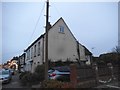
1
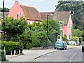
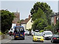
Thorpe-le-Soken High Street (Rose and Crown)
Image: © David Dixon
Taken: 2 Aug 2013
0.13 miles
2
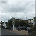
Sign and car park for the Rose and Crown inn, Thorpe-le-Soken
On the right, there is an advert for "Piano Night" on both Thursday Lunch and Thursday Evening
Image: © David Smith
Taken: 16 Jun 2014
0.14 miles
3
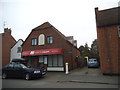
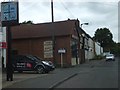
House of Colour, Thorpe-le-Soken
They're colour consultants. No, I don't know either.
Image: © David Howard
Taken: 4 Apr 2017
0.16 miles
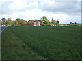
6
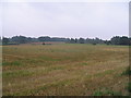
Barley field
Just stubble left, after harvest at Thorpe-le-Soken.
Image: © M J Richardson
Taken: 21 Aug 2007
0.22 miles
7
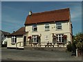
'The Rose & Crown' inn, Thorpe-le-Soken, Essex
Image: © Robert Edwards
Taken: 3 Jul 2006
0.23 miles
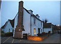
10
Thorpe-le-Soken village sign and shops
Image: © David Smith
Taken: 16 Jun 2014
0.24 miles