IMAGES TAKEN NEAR TO
Mistley Road, CLACTON-ON-SEA, CO16 0DB
Introduction
This page details the photographs taken nearby to Mistley Road, CO16 0DB by members of the Geograph project.
The Geograph project started in 2005 with the aim of publishing, organising and preserving representative images for every square kilometre of Great Britain, Ireland and the Isle of Man.

There are currently over 7.5m images from over14,400 individuals and you can help contribute to the project by visiting https://www.geograph.org.uk
Image Map (Loading...)


Getting Data...Please wait
Leaflet Map data © OpenStreetMap
Images are licensed for reuse under creativecommons.org/licenses/by-sa/2.0
Notes
- Clicking on the map will re-center to the selected point.
- The higher the marker number, the further away the image location is from the centre of the postcode.
Image Listing (8 Images Found)
Images are licensed for reuse under creativecommons.org/licenses/by-sa/2.0
Image
Details
Distance
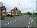
1
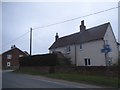
Houses on Little Bentley Road, Tendring
Image: © David Howard
Taken: 4 Apr 2017
0.18 miles
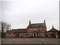
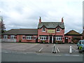
3
Tendring Heath B1035
Looking towards Tendring the B1035. Heath Hospital the former Workhouse entrance middle picture.
Image: © roger geach
Taken: 31 Oct 2012
0.20 miles