IMAGES TAKEN NEAR TO
Thorpe Road, CLACTON-ON-SEA, CO16 0AJ
Introduction
This page details the photographs taken nearby to Thorpe Road, CO16 0AJ by members of the Geograph project.
The Geograph project started in 2005 with the aim of publishing, organising and preserving representative images for every square kilometre of Great Britain, Ireland and the Isle of Man.

There are currently over 7.5m images from over14,400 individuals and you can help contribute to the project by visiting https://www.geograph.org.uk
Image Map
Images are licensed for reuse under creativecommons.org/licenses/by-sa/2.0
Notes
- Clicking on the map will re-center to the selected point.
- The higher the marker number, the further away the image location is from the centre of the postcode.
Image Listing (7 Images Found)
Images are licensed for reuse under creativecommons.org/licenses/by-sa/2.0
Image
Details
Distance
1
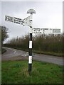
Direction Sign ? Signpost on the B1035 in Beaumont cum Moze parish
Located on a grass triangle in the centre of the T junction of the B1035 Thorpe Road and Swan Road in Beaumont cum Moze parish. 3 arms and half-moon finial.
Milestone Society National ID: EX_TM1624
Image: © John V Nicholls
Taken: 15 Mar 2004
0.03 miles
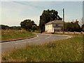
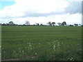
3
Swan Road, near Beaumont
Swan Road, in north Essex countryside between Tendring and Beaumont.
Image: © Malc McDonald
Taken: 18 Jul 2015
0.13 miles
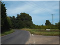
6
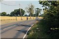
Along the B1035 road to Thorpe Green
Nice evening for a cycle, pity the cars spoil it.
Image: © roger geach
Taken: 11 Jul 2008
0.21 miles
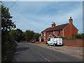
7
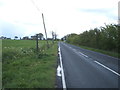
Footpath off Tendring Road (B1035)
Looking south east.
Image: © JThomas
Taken: 26 Apr 2017
0.21 miles