IMAGES TAKEN NEAR TO
Holland Park, CLACTON-ON-SEA, CO15 6LP
Introduction
This page details the photographs taken nearby to Holland Park, CO15 6LP by members of the Geograph project.
The Geograph project started in 2005 with the aim of publishing, organising and preserving representative images for every square kilometre of Great Britain, Ireland and the Isle of Man.

There are currently over 7.5m images from over14,400 individuals and you can help contribute to the project by visiting https://www.geograph.org.uk
Image Map
Images are licensed for reuse under creativecommons.org/licenses/by-sa/2.0
Notes
- Clicking on the map will re-center to the selected point.
- The higher the marker number, the further away the image location is from the centre of the postcode.
Image Listing (4 Images Found)
Images are licensed for reuse under creativecommons.org/licenses/by-sa/2.0
Image
Details
Distance
1
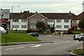
Road junction at Great Clacton, Essex
This is where the B.1032 meets the B.1027
Image: © Robert Edwards
Taken: 4 Oct 2006
0.13 miles
4
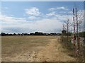
Eastcliff Sports Ground from north-east corner
The photograph shows a view of Eastcliff Sports Ground from its north-east corner, a few steps off the footpath 'Sea Lane' which runs by it and the end of Dulwich Road (both behind me when I took the picture).
In the distance is housing on Gainsford Avenue (to right of picture) and Third Avenue. To the right in the middle distance is a children's play area with climbing frames and swings. At the right hand edge of the photograph is a boundary hedge, beyond which are floodlights and another playing field.
See Image and Image
Image: © Duncan Graham
Taken: 18 Jul 2018
0.25 miles