IMAGES TAKEN NEAR TO
Frinton Road, CLACTON-ON-SEA, CO15 5UN
Introduction
This page details the photographs taken nearby to Frinton Road, CO15 5UN by members of the Geograph project.
The Geograph project started in 2005 with the aim of publishing, organising and preserving representative images for every square kilometre of Great Britain, Ireland and the Isle of Man.

There are currently over 7.5m images from over14,400 individuals and you can help contribute to the project by visiting https://www.geograph.org.uk
Image Map (Loading...)


Getting Data...Please wait
Leaflet Map data © OpenStreetMap
Images are licensed for reuse under creativecommons.org/licenses/by-sa/2.0
Notes
- Clicking on the map will re-center to the selected point.
- The higher the marker number, the further away the image location is from the centre of the postcode.
Image Listing (3 Images Found)
Images are licensed for reuse under creativecommons.org/licenses/by-sa/2.0
Image
Details
Distance
1
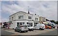
Shops and post office at junction of Stratford and Frinton Roads
The distinctive architecture of between the world wars
Image: © David Smith
Taken: 31 May 2017
0.06 miles
2
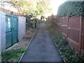
Holland-on-Sea: Footpath between Frinton Road and Slade Road
This footpath runs at the back of the houses between Frinton Road and Slade Road, and this is the view from the Slade Road end.
Old large scale Ordnance Survey maps show that a footpath and public right of way existed here long before there was any residential development.
Image: © Nigel Cox
Taken: 27 Oct 2018
0.18 miles