IMAGES TAKEN NEAR TO
Broadmere Close, CLACTON-ON-SEA, CO15 5RL
Introduction
This page details the photographs taken nearby to Broadmere Close, CO15 5RL by members of the Geograph project.
The Geograph project started in 2005 with the aim of publishing, organising and preserving representative images for every square kilometre of Great Britain, Ireland and the Isle of Man.

There are currently over 7.5m images from over14,400 individuals and you can help contribute to the project by visiting https://www.geograph.org.uk
Image Map (Loading...)


Getting Data...Please wait
Leaflet Map data © OpenStreetMap
Images are licensed for reuse under creativecommons.org/licenses/by-sa/2.0
Notes
- Clicking on the map will re-center to the selected point.
- The higher the marker number, the further away the image location is from the centre of the postcode.
Image Listing (3 Images Found)
Images are licensed for reuse under creativecommons.org/licenses/by-sa/2.0
Image
Details
Distance
1
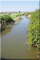
Upstream on Holland Brook
Taken from Holland Bridge on the B1032.
Image: © Glyn Baker
Taken: 20 May 2023
0.02 miles
2
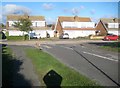
Holland-on-Sea: Fleetwood Road & Norfolk Avenue junction
Large scale Ordnance Survey maps show that this area was just fields in 1939, but by 1952 they show that the whole current estate, including these roads and houses, had been built.
Image: © Nigel Cox
Taken: 27 Oct 2018
0.06 miles
3
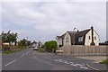
Junction of Park Road and Aylesbury Drive, Holland-on-Sea
Seen from the B1032, which parallels Aylesbury Drive
Image: © David Smith
Taken: 31 May 2017
0.25 miles