IMAGES TAKEN NEAR TO
Marine Parade East, CLACTON-ON-SEA, CO15 5AF
Introduction
This page details the photographs taken nearby to Marine Parade East, CO15 5AF by members of the Geograph project.
The Geograph project started in 2005 with the aim of publishing, organising and preserving representative images for every square kilometre of Great Britain, Ireland and the Isle of Man.

There are currently over 7.5m images from over14,400 individuals and you can help contribute to the project by visiting https://www.geograph.org.uk
Image Map (Loading...)


Getting Data...Please wait
Leaflet Map data © OpenStreetMap
Images are licensed for reuse under creativecommons.org/licenses/by-sa/2.0
Notes
- Clicking on the map will re-center to the selected point.
- The higher the marker number, the further away the image location is from the centre of the postcode.
Image Listing (17 Images Found)
Images are licensed for reuse under creativecommons.org/licenses/by-sa/2.0
Image
Details
Distance
2
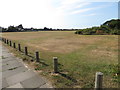
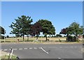
Eastcliff Sports Ground
Picture taken from the south-east corner of the Eastcliff Sports Ground, standing on the pavement at the end of Kings Parade by the entrance to the public footpath "Sea Lane".
See Image
A sports pavilion (boarded up) is visible in the middle distance to the left of picture, beside a Union Jack (flown from a neighbouring house). Beyond the sports ground is housing on Third Avenue and Gainsford Avenue. There is a fenced children's play area with climbing frames and swings beyond the bushes to the right (not visible in picture). On the horizon, to the right towering behind the bushes, you can see floodlights on the edge of the neighbouring playing field separated by a hedge.
Image: © Duncan Graham
Taken: 3 Jul 2018
0.09 miles
3
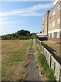
Footpath, Eastcliff Sports Ground - entrance
The photograph shows the footpath 'Sea Lane' to the east of Eastcliff Sports Ground. The footpath runs from Kings Parade (where the picture was taken, my back to the promenade and sea) to Holland Road. 'Sea Lane' intersects or is accessible from the end of Dulwich Road, Howard Road, Deanhill Avenue and Turpins Close. The footpath is 0.72 km long (according to a Tendring District Council estimate) and is currently slightly overgrown. It marks the boundary between Clacton-on-Sea and Holland-on-Sea.
Flats on Lyndhurst Road leading off the seafront are to right of picture.
Image: © Duncan Graham
Taken: 3 Jul 2018
0.11 miles
7
Eastcliff Sports Ground - view from entrance
The picture shows a view of Eastcliff Sports Ground, taken from First Avenue, Eastcliff and Gainsford Avenues leading off to the left and Third Avenue to right in the middle ground of the picture.
A children's fenced play area is just visible to the left of picture within the sports ground. You can also see floodlights behind the hedge beyond the children's area over the neighbouring playing field.
See Image
Image: © Duncan Graham
Taken: 8 Jul 2018
0.12 miles
8
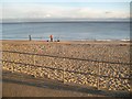
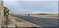
Clacton-on-Sea: Sea fishermen near Gunfleet Sailing Club
The Gunfleet Sands Wind Farm is visible on the horizon.
Image: © Nigel Cox
Taken: 27 Oct 2018
0.12 miles
9
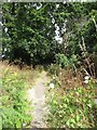
Footpath, Eastcliff Sports Ground
The photograph shows the footpath 'Sea Lane' to the east of Eastcliff Sports Ground.
See Image
Image: © Duncan Graham
Taken: 9 Jul 2018
0.13 miles