IMAGES TAKEN NEAR TO
Newington Gardens, CLACTON-ON-SEA, CO15 4UP
Introduction
This page details the photographs taken nearby to Newington Gardens, CO15 4UP by members of the Geograph project.
The Geograph project started in 2005 with the aim of publishing, organising and preserving representative images for every square kilometre of Great Britain, Ireland and the Isle of Man.

There are currently over 7.5m images from over14,400 individuals and you can help contribute to the project by visiting https://www.geograph.org.uk
Image Map
Images are licensed for reuse under creativecommons.org/licenses/by-sa/2.0
Notes
- Clicking on the map will re-center to the selected point.
- The higher the marker number, the further away the image location is from the centre of the postcode.
Image Listing (3 Images Found)
Images are licensed for reuse under creativecommons.org/licenses/by-sa/2.0
Image
Details
Distance
3
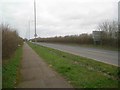
Great Clacton: B1442 Centenary Way
This section of the B1442 is a new link road, dating from the 1990s (?), that connects the A133 with the northern and eastern residential and industrial areas of Clacton.
Image: © Nigel Cox
Taken: 16 Mar 2019
0.21 miles