IMAGES TAKEN NEAR TO
Woodlands Close, CLACTON-ON-SEA, CO15 4RS
Introduction
This page details the photographs taken nearby to Woodlands Close, CO15 4RS by members of the Geograph project.
The Geograph project started in 2005 with the aim of publishing, organising and preserving representative images for every square kilometre of Great Britain, Ireland and the Isle of Man.

There are currently over 7.5m images from over14,400 individuals and you can help contribute to the project by visiting https://www.geograph.org.uk
Image Map (Loading...)


Getting Data...Please wait
Leaflet Map data © OpenStreetMap
Images are licensed for reuse under creativecommons.org/licenses/by-sa/2.0
Notes
- Clicking on the map will re-center to the selected point.
- The higher the marker number, the further away the image location is from the centre of the postcode.
Image Listing (10 Images Found)
Images are licensed for reuse under creativecommons.org/licenses/by-sa/2.0
Image
Details
Distance
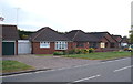
1
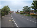
The junction where Gorse Lane meets Burrs Road
Image: © Robert Edwards
Taken: 10 May 2007
0.14 miles
2
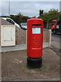
Elizabeth II postbox on Burrs Road
Outside the Burrsville Park Post Office.
Postbox No. CO15 80.
See Image] for context.
Image: © JThomas
Taken: 26 Apr 2017
0.16 miles
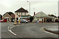
3
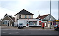
Burrsville Park Post Office
On Burrs Road.
Showing position of Postbox No. CO15 80.
See Image] for postbox.
Image: © JThomas
Taken: 26 Apr 2017
0.16 miles
6
Railway towards Clacton
Looking south west from the level crossing on Burrs Road.
Image: © JThomas
Taken: 26 Apr 2017
0.23 miles
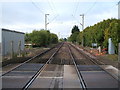
8
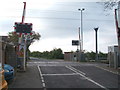
Level crossing on Burrs Road
Looking south east.
Image: © JThomas
Taken: 26 Apr 2017
0.24 miles
9
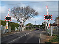
Level crossing on Burrs Road
Looking north west.
Image: © JThomas
Taken: 26 Apr 2017
0.24 miles