IMAGES TAKEN NEAR TO
Burrs Road, CLACTON-ON-SEA, CO15 4LQ
Introduction
This page details the photographs taken nearby to Burrs Road, CO15 4LQ by members of the Geograph project.
The Geograph project started in 2005 with the aim of publishing, organising and preserving representative images for every square kilometre of Great Britain, Ireland and the Isle of Man.

There are currently over 7.5m images from over14,400 individuals and you can help contribute to the project by visiting https://www.geograph.org.uk
Image Map
Images are licensed for reuse under creativecommons.org/licenses/by-sa/2.0
Notes
- Clicking on the map will re-center to the selected point.
- The higher the marker number, the further away the image location is from the centre of the postcode.
Image Listing (4 Images Found)
Images are licensed for reuse under creativecommons.org/licenses/by-sa/2.0
Image
Details
Distance
1
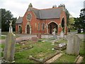
Great Clacton: Burrs Road Cemetery Chapel
The Cemetery is operated by Tendring District Council.
The photographer is unable to offer any genealogical research in the cemetery,
Image: © Nigel Cox
Taken: 16 Mar 2019
0.24 miles
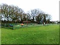
3
Cemetery Near Burrsville Park
One of two Cemeteries in Burrs Rd Clacton
Image: © Glyn Baker
Taken: 7 Jul 2013
0.25 miles
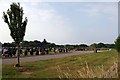
4
Across Burrsville Park
Looking towards the Earls Hall Wind Farm in the far distance http://www.renewables-map.co.uk/details.asp?pageid=143
Image: © Glyn Baker
Taken: 7 Jul 2013
0.25 miles