IMAGES TAKEN NEAR TO
Oak Close, CLACTON-ON-SEA, CO15 4EW
Introduction
This page details the photographs taken nearby to Oak Close, CO15 4EW by members of the Geograph project.
The Geograph project started in 2005 with the aim of publishing, organising and preserving representative images for every square kilometre of Great Britain, Ireland and the Isle of Man.

There are currently over 7.5m images from over14,400 individuals and you can help contribute to the project by visiting https://www.geograph.org.uk
Image Map (Loading...)


Getting Data...Please wait
Leaflet Map data © OpenStreetMap
Images are licensed for reuse under creativecommons.org/licenses/by-sa/2.0
Notes
- Clicking on the map will re-center to the selected point.
- The higher the marker number, the further away the image location is from the centre of the postcode.
Image Listing (10 Images Found)
Images are licensed for reuse under creativecommons.org/licenses/by-sa/2.0
Image
Details
Distance
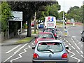
1
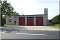
Clacton fire station
Clacton fire station, St Johns Road, Clacton-on-Sea, Essex
Image: © Kevin Hale
Taken: 5 Jun 2010
0.13 miles
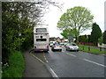
5
London Road approaching St John's Roundabout, Great Clacton
Image: © David Dixon
Taken: 2 Aug 2013
0.17 miles
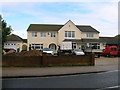
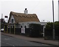
6

The Robin Hood Public House
On the London Road, Great Clacton
Image: © Phil Gaskin
Taken: 5 Jul 2011
0.17 miles
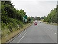
7

The B1027 at Great Clacton
This view shows the direction to St Osyth.
Image: © Robert Edwards
Taken: 10 May 2007
0.18 miles
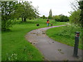
10
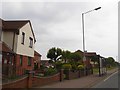
Bus shelter, B1027, east of junction with Constable Avenue
The stop serves a modern estate, several of whose roads are named after artists
Image: © David Smith
Taken: 31 May 2017
0.23 miles