IMAGES TAKEN NEAR TO
Sladburys Lane, CLACTON-ON-SEA, CO15 4BE
Introduction
This page details the photographs taken nearby to Sladburys Lane, CO15 4BE by members of the Geograph project.
The Geograph project started in 2005 with the aim of publishing, organising and preserving representative images for every square kilometre of Great Britain, Ireland and the Isle of Man.

There are currently over 7.5m images from over14,400 individuals and you can help contribute to the project by visiting https://www.geograph.org.uk
Image Map (Loading...)


Getting Data...Please wait
Leaflet Map data © OpenStreetMap
Images are licensed for reuse under creativecommons.org/licenses/by-sa/2.0
Notes
- Clicking on the map will re-center to the selected point.
- The higher the marker number, the further away the image location is from the centre of the postcode.
Image Listing (3 Images Found)
Images are licensed for reuse under creativecommons.org/licenses/by-sa/2.0
Image
Details
Distance
1

Footbridge over Picker's Ditch
The footbridge carries Great Clacton Footpath 27 over Image
Image: © Glyn Baker
Taken: 20 May 2023
0.08 miles
3
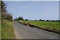
Beet Field by Sladbury's Lane
Looking towards Smythies Farm.
Image: © Glyn Baker
Taken: 30 Sep 2023
0.22 miles