IMAGES TAKEN NEAR TO
Lodge Close, CLACTON-ON-SEA, CO15 3HU
Introduction
This page details the photographs taken nearby to Lodge Close, CO15 3HU by members of the Geograph project.
The Geograph project started in 2005 with the aim of publishing, organising and preserving representative images for every square kilometre of Great Britain, Ireland and the Isle of Man.

There are currently over 7.5m images from over14,400 individuals and you can help contribute to the project by visiting https://www.geograph.org.uk
Image Map
Images are licensed for reuse under creativecommons.org/licenses/by-sa/2.0
Notes
- Clicking on the map will re-center to the selected point.
- The higher the marker number, the further away the image location is from the centre of the postcode.
Image Listing (13 Images Found)
Images are licensed for reuse under creativecommons.org/licenses/by-sa/2.0
Image
Details
Distance
1
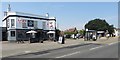
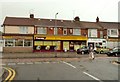
Queen's Arms public house
The picture shows The Queen's Arms public house in Old Road, taken from across the street.
To the right, beyond the bus shelter, are Magdalen Green public toilets (brick-built, disused for a few months prior to the photograph being taken) and, just visible, Magdalen Green Post Office (white building).
Magdalen Green is the name of the pre-existing hamlet in this area subsumed into Clacton-on-Sea as the new town expanded from 1871.
Image: © Duncan Graham
Taken: 27 Jul 2018
0.08 miles
2
Magdalen Green toilets and Post Office
This picture was taken from the other side of Old Road. The toilets (disused for a few months prior to this photograph being taken) are the brick-built building; the Post Office is to the right. The Post Office is marked on a map of 1896.
Magdalen Green is the name of the pre-existing hamlet here absorbed into Clacton-on-Sea as the new seaside resort expanded from 1871 onwards.
Image: © Duncan Graham
Taken: 27 Jul 2018
0.08 miles
3
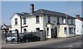
The Griffin free house
This picture shows The Griffin public house in Old Road, taken from the opposite side of the street.
The pub was originally called "The Coach and Horses" and is marked as such on a map of 1874.
In 2009, Linda Lockert-Smith reopened it as a bar and music venue, named "Ronnie's Bar" as a tribute to her father, the jazz musician Ronnie Smith, but the business closed after three years.
It was renamed Hope's Bar (about 2013-16) and Kaz's Bar before taking its present name.
[Sources: OS map 1874, Clacton Gazette, 2012-16, personal recollection].
Image: © Duncan Graham
Taken: 27 Jul 2018
0.09 miles
4
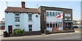
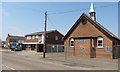
Comrades' Club, Old Road
The picture shows the Comrades' Sports and Social Club in Old Road, taken from the opposite side of the street.
The club was founded in 1920 by former servicemen following the end of the First World War. The original branch of the Comrades' Club is in Colne Road, Clacton; both premises are still in use. The Old Road building in this photograph was formerly a church, originally a Primitive Methodists' Chapel for approximately 40 years from 1863.
[Sources: comradesclubclacton.co.uk; "The History of Clacton" by Kenneth Walker, 1966].
Image: © Duncan Graham
Taken: 27 Jul 2018
0.10 miles
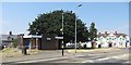
6
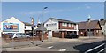
St Andrew's Hall - looking northwest
A former church in St Andrew's Road (built in 1893 as St Andrew's Mission Hall and originally used by the Church Army, a Church of England evangelistic organisation). It is now used as a community hall for hire, containing the hall proper, a classroom, kitchen, toilets and changing-rooms.
The East of England Co-op Funeral Services building, to the left of picture next door, appears to have been part of the same set of church buildings. (It has a matching spire and a cross painted on an exterior wall, neither visible here; see Image).
[Source for details of original use of hall and construction date: Kelly's Directory of Essex, 1902].
Image: © Duncan Graham
Taken: 27 Jul 2018
0.18 miles
7
St Andrew's Hall - looking northeast
A former church in St Andrew's Road (built in 1893 as St Andrew's Mission Hall and originally used by the Church Army, a Church of England evangelistic organisation). It is now used as a community hall for hire, containing the hall proper, a classroom, kitchen, toilets and changing-rooms.
The East of England Co-op Funeral Services building, to the left of picture next door, appears to have been part of the same set of church buildings. (Note it has a matching spire and a cross painted on an exterior wall). See Image
[Source for details of original use of hall and construction date: Kelly's Directory of Essex, 1902].
Image: © Duncan Graham
Taken: 27 Jul 2018
0.18 miles
9
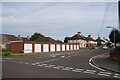
Lockups in Wargrave Rd
I would be willing to take a small wager that not one of these garages shelters an automobile (unless it is a treasured classic). I am convinced they will all be full to the brim of piles of "stuff" that will come in handy one day!
Image: © Glyn Baker
Taken: 30 Sep 2023
0.23 miles
10
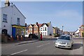
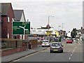
Bike Shop in Harrow Road
Looking Across the A133 towards Cambridge Rd.
Image: © Glyn Baker
Taken: 30 Sep 2023
0.23 miles