IMAGES TAKEN NEAR TO
St. Osyth Road, CLACTON-ON-SEA, CO15 3HJ
Introduction
This page details the photographs taken nearby to St. Osyth Road, CO15 3HJ by members of the Geograph project.
The Geograph project started in 2005 with the aim of publishing, organising and preserving representative images for every square kilometre of Great Britain, Ireland and the Isle of Man.

There are currently over 7.5m images from over14,400 individuals and you can help contribute to the project by visiting https://www.geograph.org.uk
Image Map (Loading...)


Getting Data...Please wait
Leaflet Map data © OpenStreetMap
Images are licensed for reuse under creativecommons.org/licenses/by-sa/2.0
Notes
- Clicking on the map will re-center to the selected point.
- The higher the marker number, the further away the image location is from the centre of the postcode.
Image Listing (6 Images Found)
Images are licensed for reuse under creativecommons.org/licenses/by-sa/2.0
Image
Details
Distance
1
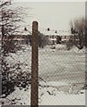
The lake by Lake Walk
The photograph shows the lake by Lake Walk and Lake Avenue, frozen at a time of heavy snowfall. The picture was taken from the pavement of Coopers Lane looking towards houses on Lake Walk visible in the background.
The outline of the lake is marked in blue on Ordnance Survey maps.
Mallards were living on and around the lake when the photograph was taken.
My father, David Graham, took the picture and was kind enough to permit me to upload it.
Image: © David L Graham
Taken: Unknown
0.11 miles
2

Seventh-Day Adventist Church
This picture shows Clacton Seventh-Day Adventist Community Church, on Rush Green Road and opposite the end of Boxted Avenue.
The church building was constructed in 1893 (the date is in the roundel above the door to right of picture). On an 1896 map of the Clacton area, the church is shown as a Wesleyan Mission Chapel, with what was then the hamlet of Coppins Green just to the north. The chapel stood by the road leading south to the hamlet of Rush Green, farmland otherwise surrounding the building. The expanding seaside resort of Clacton-on-Sea has since engulfed the farmland and small settlements.
Image: © Duncan Graham
Taken: 27 Jul 2018
0.13 miles
3

Clacton-on-Sea: Seventh-day Adventist Church
This building was originally the Wesleyan Mission Chapel and when it was built it was the only non-agricultural building in the hamlet of Coppen's Green. It was not until the 1950s that the urban residential development of Clacton-on-Sea began to catch up with it.
It has recently been refurbished by the Seventh-day Adventist Church, and, as can be judged by the number of vehicles in the car park, the Saturday afternoon Bible study sessions are popular.
The church's website is here http://clacton.adventistchurch.org.uk/
The road is Rush Green Road.
Image: © Nigel Cox
Taken: 16 Mar 2019
0.13 miles
4
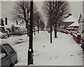
Jameson Road in the snow
A residential street under heavy snowfall. The photograph was taken just before turning into Lake Avenue, near the St Osyth Road end of the street, but looking back in the direction of Coopers Lane.
My father David Graham took this photograph and was kind enough to let me upload it. See also Image .
Image: © David L Graham
Taken: Unknown
0.18 miles
5
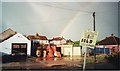
Jameson Road and rainbow
This photograph shows a boat-house (with black double-doors), garages and a house near the Coopers Lane end of Jameson Road; behind them the backs of houses on St. Osyth Road are visible. Fishing tackle sits in front of the boat-house.
Above is a rainbow.
The picture was taken from a front garden on the opposite side of the street. My apologies that the "sold" sign intrudes.
Image: © Duncan Graham
Taken: 30 Apr 2003
0.23 miles
6
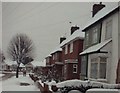
Jameson Road in snow
A residential street under a heavy snowfall, looking towards Coopers Lane. The row of 1930s-built red-brick houses (Nos. 1-11) were originally police houses; one police officer and his family were still living there in 1994.
My father David Graham took this photograph and was kind enough to let me upload it.
Image: © David L Graham
Taken: Unknown
0.24 miles