IMAGES TAKEN NEAR TO
Stanley Road, CLACTON-ON-SEA, CO15 2BS
Introduction
This page details the photographs taken nearby to Stanley Road, CO15 2BS by members of the Geograph project.
The Geograph project started in 2005 with the aim of publishing, organising and preserving representative images for every square kilometre of Great Britain, Ireland and the Isle of Man.

There are currently over 7.5m images from over14,400 individuals and you can help contribute to the project by visiting https://www.geograph.org.uk
Image Map
Images are licensed for reuse under creativecommons.org/licenses/by-sa/2.0
Notes
- Clicking on the map will re-center to the selected point.
- The higher the marker number, the further away the image location is from the centre of the postcode.
Image Listing (1 Images Found)
Images are licensed for reuse under creativecommons.org/licenses/by-sa/2.0
Image
Details
Distance
1
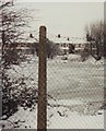
The lake by Lake Walk
The photograph shows the lake by Lake Walk and Lake Avenue, frozen at a time of heavy snowfall. The picture was taken from the pavement of Coopers Lane looking towards houses on Lake Walk visible in the background.
The outline of the lake is marked in blue on Ordnance Survey maps.
Mallards were living on and around the lake when the photograph was taken.
My father, David Graham, took the picture and was kind enough to permit me to upload it.
Image: © David L Graham
Taken: Unknown
0.24 miles