IMAGES TAKEN NEAR TO
Anchor Road, CLACTON-ON-SEA, CO15 1HT
Introduction
This page details the photographs taken nearby to Anchor Road, CO15 1HT by members of the Geograph project.
The Geograph project started in 2005 with the aim of publishing, organising and preserving representative images for every square kilometre of Great Britain, Ireland and the Isle of Man.

There are currently over 7.5m images from over14,400 individuals and you can help contribute to the project by visiting https://www.geograph.org.uk
Image Map
Images are licensed for reuse under creativecommons.org/licenses/by-sa/2.0
Notes
- Clicking on the map will re-center to the selected point.
- The higher the marker number, the further away the image location is from the centre of the postcode.
Image Listing (27 Images Found)
Images are licensed for reuse under creativecommons.org/licenses/by-sa/2.0
Image
Details
Distance
3
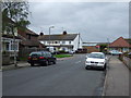
Footpath from Alton Park Road to Coopers Lane, Clacton-on-Sea
This public footpath or alley runs from Alton Park Road (near the entrance to Ford Road) to Coopers Lane. The picture was taken from the opposite pavement on Alton Park Road looking towards the footpath entrance.
On the left are houses on Alton Park Road; in the centre the footpath; on the right Ford Road and buildings in the industrial estate along it, with someone's parked car on Alton Park Road on far right.
To the southwest of the footpath are allotments.
Image: © Duncan Graham
Taken: 16 Feb 2018
0.05 miles
4
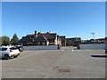
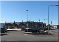
Tendring Adult Education College, St Osyth Road, Clacton-on-Sea
Photograph taken from the Alton Park Road car park looking east. The side and part of the rear of the building are visible; so is part of the car park belonging to the college, through the gates and beyond the low boundary walls, which was formerly the school playground.
The houses visible behind the college to the right are on Castle Road.
Image: © Duncan Graham
Taken: 12 Feb 2018
0.12 miles
5
Tendring Adult Education College, St Osyth Road, Clacton-on-Sea
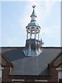
A close up of one of the former school's bell-towers.
The picture was taken from the other side of St Osyth Road.
Image: © Duncan Graham
Taken: 27 Jul 2018
0.12 miles
6
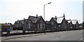
Tendring Adult Education College, St Osyth Road, Clacton-on-Sea
This picture was taken from the other side of St Osyth Road, looking south-west in the sunshine.
Image: © Duncan Graham
Taken: 27 Jul 2018
0.12 miles
7
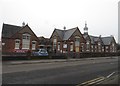
Tendring Adult Education College, St Osyth Road, Clacton-on-Sea
Built in 1893, this building was St Osyth Road School from 1894 to 1997 and reopened as Tendring Adult Education College in 2002.
The school educated children up to the age of 11 until 1952 and was afterwards an infant school, the older children transferring to the newly built Alton Park Junior School. The children and staff moved to the new Oakwood Infants' School off Windsor Avenue in 1997.
The lintel above the doorway marked "Entrance" in this photograph originally read "BOYS", the girls' entrance, as you can see in the highest resolutions of the picture, being next to it.
[Sources: "St Osyth Road School Clacton-on-Sea 1893 - 1993: A Centenary Celebration" by Elizabeth Hermon, 1993; Evening Gazette, 2002].
Image: © Duncan Graham
Taken: 26 Jan 2018
0.12 miles
8
Tendring Adult Education College, St Osyth Road, Clacton-on-Sea
Built in 1893, this building was St Osyth Road School from 1894 to 1997 and reopened as Tendring Adult Education College in 2002.
The school educated children up to the age of 11 until 1952 and was afterwards an infant school, the older children transferring to the newly built Alton Park Junior School. The children and staff moved to the new Oakwood Infants' School off Windsor Avenue in 1997.
[Sources: "St Osyth Road School Clacton-on-Sea 1893 - 1993: A Centenary Celebration" by Elizabeth Hermon, 1993; Evening Gazette, 2002].
Image: © Duncan Graham
Taken: 26 Jan 2018
0.12 miles
9
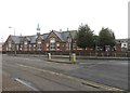
Tendring Adult Education College, St Osyth Road, Clacton-on-Sea
Photograph taken from the Lidl car park looking west; the edge of the Lidl building is visible on the left hand edge. Houses on Alton Park Road can be seen on the right. The Salvation Army citadel was behind me.
Image: © Duncan Graham
Taken: 12 Feb 2018
0.13 miles
10
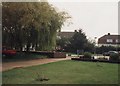
Alton Park Junior School grounds: looking towards entrance on Alton Park Road
This photograph shows the school grounds looking towards the gates with houses on Alton Park Road beyond, with two magnificent willows to the left of the path.
The two sets of white and red metal grilles just discernible behind the trees are the open gates at the entrance to the school property, one entrance for pedestrians, the other for motor traffic. The footpath just behind the brick-walled shrub beds led from the pedestrian gates to the main school entrance. The path clearly visible running to the left of the photograph led to the demountable classrooms shown in geograph Image
The willows are no longer there and the area is significantly changed, with a greater number of car parking spaces (I looked on Google Street View for the purpose of providing context to the photograph).
Taken as part of a photography exercise as a ten-year-old pupil; I remember the staff member with whom I worked fondly.
Image: © Duncan Graham
Taken: 13 Sep 1995
0.13 miles