IMAGES TAKEN NEAR TO
Agar Road, WALTON ON THE NAZE, CO14 8DJ
Introduction
This page details the photographs taken nearby to Agar Road, CO14 8DJ by members of the Geograph project.
The Geograph project started in 2005 with the aim of publishing, organising and preserving representative images for every square kilometre of Great Britain, Ireland and the Isle of Man.

There are currently over 7.5m images from over14,400 individuals and you can help contribute to the project by visiting https://www.geograph.org.uk
Image Map (Loading...)


Getting Data...Please wait
Leaflet Map data © OpenStreetMap
Images are licensed for reuse under creativecommons.org/licenses/by-sa/2.0
Notes
- Clicking on the map will re-center to the selected point.
- The higher the marker number, the further away the image location is from the centre of the postcode.
Image Listing (202 Images Found)
Images are licensed for reuse under creativecommons.org/licenses/by-sa/2.0
Image
Details
Distance
1
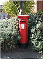
Elizabeth II postbox, Walton on the Naze Railway Station
Postbox No. CO14 50.
Image: © JThomas
Taken: 26 Apr 2017
0.03 miles
2
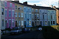
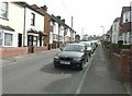
Crescent Road, Walton-on-the-Naze
Image: © Christopher Hilton
Taken: 5 Aug 2018
0.03 miles
3
Clapboard houses near Walton-on-the-Naze Railway Station
Image: © JThomas
Taken: 26 Apr 2017
0.03 miles
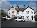
4
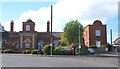
Walton-on-the-Naze: The former railway station building
Walton still has its functioning railway station, seen here Image, but this building next door, now converted into residential accommodation, is the original Great Eastern Railway structure. The local photographic firm of Putmans have an image from the same viewpoint dated 1984 here http://www.putmans.co.uk/OldWalton_sundry_Assetts/926-Railway-Stn-1984.jpg which shows the building in use as the station. Since then the domed roof and block above the original entrance have been added, although another old photograph in Putmans' archive http://www.putmans.co.uk/OldWalton_sundry_Assetts/933-Walton-Station.jpg taken from a different angle would suggest that a tower there was part of the original fabric of the building anyway.
The station name in the 1984 image is Walton-on-Naze. This did not change until 2007 when it became the current Walton-on-the-Naze.
Image: © Nigel Cox
Taken: 30 Aug 2009
0.04 miles
5
Walton on the Naze Railway Station
Showing position of Postbox No. CO14 50.
Image: © JThomas
Taken: 26 Apr 2017
0.04 miles
6
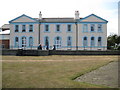
Walton-on-the-Naze: The former Station Lounge
I am not sure of the original function of this building. It was obviously part of the fabric of the original Great Eastern Railway terminus station, and the size of it suggests that it was an hotel. There is a view of the rear of the building, from the station side, probably in its Edwardian heyday, in the archive of the local photographic firm of Putmans here http://www.putmans.co.uk/OldWalton_sundry_Assetts/935-Railway-Station.jpg
Another from Putmans again here http://www.putmans.co.uk/OldWalton_sundry_Assetts/928-Station-Lounge%20and%20Garden.jpg show it as a public house called the Station Lounge.
Image: © Nigel Cox
Taken: 30 Aug 2009
0.04 miles
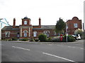
7
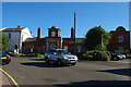
Walton-on-the-Naze: former Great Eastern Railway station
The former railway station building seen here is now converted to residential accommodation; the station still exists behind this.
Image: © Christopher Hilton
Taken: 5 Aug 2018
0.04 miles
8
Looking south-southeast along Church Road
Towards Walton-on-the-Naze railway station, which can be seen at the top of the road.
Image: © John Baker
Taken: 30 Mar 2014
0.05 miles
9

Walton-on-the-Naze Station, exterior
View SW, towards Thorpe-le-Soken: ex-GER terminus of line from Colchester via Thorpe-le-Soken, electrified 1959.
Image: © Ben Brooksbank
Taken: 20 Sep 2008
0.05 miles
10
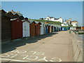
Beach Huts, Walton-on-the-Naze
Hundreds of beach huts are crammed tightly together in rows above the sea wall.
Image: © Robin Lucas
Taken: 8 May 2008
0.05 miles