IMAGES TAKEN NEAR TO
CO13 9QL
Introduction
This page details the photographs taken nearby to CO13 9QL by members of the Geograph project.
The Geograph project started in 2005 with the aim of publishing, organising and preserving representative images for every square kilometre of Great Britain, Ireland and the Isle of Man.

There are currently over 7.5m images from over14,400 individuals and you can help contribute to the project by visiting https://www.geograph.org.uk
Image Map
Images are licensed for reuse under creativecommons.org/licenses/by-sa/2.0
Notes
- Clicking on the map will re-center to the selected point.
- The higher the marker number, the further away the image location is from the centre of the postcode.
Image Listing (112 Images Found)
Images are licensed for reuse under creativecommons.org/licenses/by-sa/2.0
Image
Details
Distance
1
Row of shops with painted advertisement on the side
Faded advert, but relatively modern as it refers to the adjacent shop with a current phone number
Image: © David Smith
Taken: 31 May 2017
0.01 miles
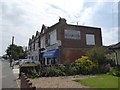
2
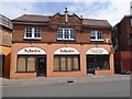
Two shops in an ornate building, Old Road, Frinton-on-Sea
Image: © David Smith
Taken: 31 May 2017
0.01 miles
4
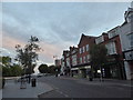
Looking along Connaught Avenue towards The Esplanade
Image: © Basher Eyre
Taken: 18 Jul 2020
0.03 miles
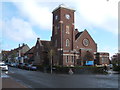
6
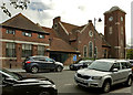
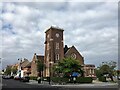
Frinton Free Church on Connaught Avenue
Image: © Roger A Smith
Taken: 12 Sep 2019
0.04 miles