IMAGES TAKEN NEAR TO
Kirby Road, FRINTON-ON-SEA, CO13 0HT
Introduction
This page details the photographs taken nearby to Kirby Road, CO13 0HT by members of the Geograph project.
The Geograph project started in 2005 with the aim of publishing, organising and preserving representative images for every square kilometre of Great Britain, Ireland and the Isle of Man.

There are currently over 7.5m images from over14,400 individuals and you can help contribute to the project by visiting https://www.geograph.org.uk
Image Map (Loading...)


Getting Data...Please wait
Leaflet Map data © OpenStreetMap
Images are licensed for reuse under creativecommons.org/licenses/by-sa/2.0
Notes
- Clicking on the map will re-center to the selected point.
- The higher the marker number, the further away the image location is from the centre of the postcode.
Image Listing (2 Images Found)
Images are licensed for reuse under creativecommons.org/licenses/by-sa/2.0
Image
Details
Distance
1
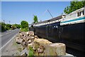
Thames Barge by the B1032
I wonder if anyone has plans for the old barge. The leeboard is clearly visible.
Image: © Glyn Baker
Taken: 20 May 2023
0.01 miles
2
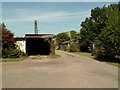
Green End Farm, near to Kirby Cross, Essex
Image: © Robert Edwards
Taken: 3 Jul 2006
0.15 miles