IMAGES TAKEN NEAR TO
Turpins Lane, FRINTON-ON-SEA, CO13 0FQ
Introduction
This page details the photographs taken nearby to Turpins Lane, CO13 0FQ by members of the Geograph project.
The Geograph project started in 2005 with the aim of publishing, organising and preserving representative images for every square kilometre of Great Britain, Ireland and the Isle of Man.

There are currently over 7.5m images from over14,400 individuals and you can help contribute to the project by visiting https://www.geograph.org.uk
Image Map
Images are licensed for reuse under creativecommons.org/licenses/by-sa/2.0
Notes
- Clicking on the map will re-center to the selected point.
- The higher the marker number, the further away the image location is from the centre of the postcode.
Image Listing (18 Images Found)
Images are licensed for reuse under creativecommons.org/licenses/by-sa/2.0
Image
Details
Distance
1
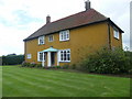
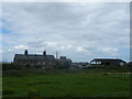
Devereux Farmhouse
Devereux farmhouse was built in the 1950s as the principal farmhouse for Devereux farm. It was built just a few hundred yards from the old farmhouse - Brick Barn farmhouse which is now a residential care home. The house is set in mature gardens and the two fields either side of the house are home to 200 chickens.
Image: © Ben Eagle
Taken: 12 Aug 2008
0.06 miles
2
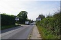
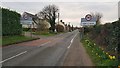
Approaching Kerby le Soken
Looking along the B1034 Walton Rd.
Image: © Glyn Baker
Taken: 16 Sep 2023
0.09 miles
3
Entering Kirby-le-Soken
Heading west on the B1034.
Image: © JThomas
Taken: 26 Apr 2017
0.09 miles
4
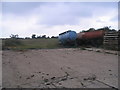
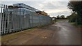
Field corner at Kirby-le-Soken
Assorted equipment parked at the field entrance.
Image: © M J Richardson
Taken: 21 Aug 2007
0.09 miles
5
Devereux Cottages
This image is the view from Devereux Farmhouse to the farm cottages and farm buildings beyond.
Image: © Ben Eagle
Taken: 12 Aug 2008
0.09 miles
6
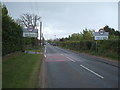
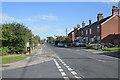
Kirby-le-Soken: B1034 Walton Road
Viewed looking westwards.
For a view from the other side of the road please see Image
Image: © Nigel Cox
Taken: 14 Mar 2020
0.11 miles
7
Kirby-le-Soken: Island Lane
This is the southern end of Island Lane, at the approach to its junction with the B1034 Walton Road.
In this section of the lane it is marked by green solid circles on the Ordnance Survey's 1:25,000 scale maps and by red solid circles on the Ordnance Survey's 1:50,000 scale maps, indicating that it is an "other route with public access".
Image: © Nigel Cox
Taken: 14 Mar 2020
0.11 miles
8
Walton Road, Kirby-le-Soken
Looking east along this main road through Kirby-le-Soken, taken from the end of Quay Lane.
Image: © Trevor Harris
Taken: 2 Oct 2022
0.14 miles
9
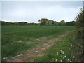
Crop field, Kirby-le-Soken
Off Island Lane.
Image: © JThomas
Taken: 26 Apr 2017
0.14 miles
10
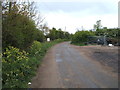
Island Lane, Kirby-le-Soken
Looking north.
Image: © JThomas
Taken: 26 Apr 2017
0.14 miles