IMAGES TAKEN NEAR TO
Wells Road, COLCHESTER, CO1 2YW
Introduction
This page details the photographs taken nearby to Wells Road, CO1 2YW by members of the Geograph project.
The Geograph project started in 2005 with the aim of publishing, organising and preserving representative images for every square kilometre of Great Britain, Ireland and the Isle of Man.

There are currently over 7.5m images from over14,400 individuals and you can help contribute to the project by visiting https://www.geograph.org.uk
Image Map (Loading...)


Getting Data...Please wait
Leaflet Map data © OpenStreetMap
Images are licensed for reuse under creativecommons.org/licenses/by-sa/2.0
Notes
- Clicking on the map will re-center to the selected point.
- The higher the marker number, the further away the image location is from the centre of the postcode.
Image Listing (40 Images Found)
Images are licensed for reuse under creativecommons.org/licenses/by-sa/2.0
Image
Details
Distance
1

Ordnance Survey Cut Mark
This OS cut mark can be found on No55A East Hill. It marks a point 5.237m above mean sea level.
Image: © Adrian Dust
Taken: 8 Jan 2020
0.07 miles
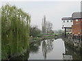
2
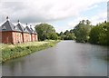
River Colne from the new footbridge at the Mill
The river viewed from the new sluice bridge behind East Street park
Image: © MJ Reilly
Taken: 18 May 2009
0.08 miles
3
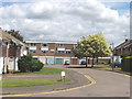
Durham Square, Colchester
An estate of modern houses between East Hill and the River Colne.
Image: © David Hawgood
Taken: 15 Jun 2006
0.11 miles
4
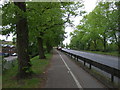
Cycle path beside Cowdray Avenue, Colchester
Looking south east.
Image: © JThomas
Taken: 24 Apr 2017
0.13 miles
5
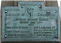
Old Bridge Marker by the A133, Cowdray Avenue, Colchester
Bridge Marker by the A133, in parish of Colchester (Colchester District), Cowdray Avenue Railway Bridge, in North parapet.
Surveyed
Milestone Society National ID: EX_COLC05br
Image: © Milestone Society
Taken: Unknown
0.14 miles
8
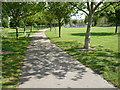
Footpath through the park, East Street, Colchester
The much improved park with access to the new bridge and Mill development.
Image: © MJ Reilly
Taken: 18 May 2009
0.15 miles
9
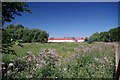
Towards Riverside Walk
One has to wonder at the wisdom of building homes on a water meadow (the clue is in the name!)
Image: © Glyn Baker
Taken: 1 Aug 2013
0.16 miles
10
The River Colne (2)
North of the East Street bridge.
Image: © Mike Quinn
Taken: 2 Apr 2014
0.18 miles