IMAGES TAKEN NEAR TO
Guildford Road, COLCHESTER, CO1 2RB
Introduction
This page details the photographs taken nearby to Guildford Road, CO1 2RB by members of the Geograph project.
The Geograph project started in 2005 with the aim of publishing, organising and preserving representative images for every square kilometre of Great Britain, Ireland and the Isle of Man.

There are currently over 7.5m images from over14,400 individuals and you can help contribute to the project by visiting https://www.geograph.org.uk
Image Map (Loading...)


Getting Data...Please wait
Leaflet Map data © OpenStreetMap
Images are licensed for reuse under creativecommons.org/licenses/by-sa/2.0
Notes
- Clicking on the map will re-center to the selected point.
- The higher the marker number, the further away the image location is from the centre of the postcode.
Image Listing (123 Images Found)
Images are licensed for reuse under creativecommons.org/licenses/by-sa/2.0
Image
Details
Distance
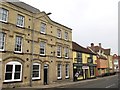
1
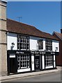
"The Goat and Boot" public house, Colchester
Grade II listed building, described at this http://list.english-heritage.org.uk/resultsingle.aspx?uid=1123658.
Image: © Jim Osley
Taken: 3 Jul 2014
0.03 miles
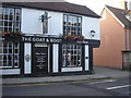
4
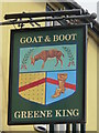
Sign for The Goat and Boot, East Hill, CO1
See Image
Image: © Mike Quinn
Taken: 2 Apr 2014
0.04 miles
6
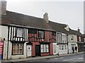
Old building at the foot of East Hill, CO1
Image: © Mike Quinn
Taken: 2 Apr 2014
0.04 miles
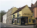
7
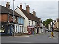
East Hill, Colchester
On the left, the East Hill Superstore.
Image: © David Smith
Taken: 31 May 2017
0.05 miles
9
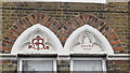
Former orphanage, East Hill, CO1 - detail
See Image
Image: © Mike Quinn
Taken: 2 Apr 2014
0.05 miles
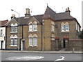
10
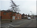
Part of Roseberry Avenue, Colchester
Where old meets newer.
Image: © Jeremy Bolwell
Taken: 12 Mar 2016
0.05 miles