IMAGES TAKEN NEAR TO
Granville Road, COLCHESTER, CO1 2EE
Introduction
This page details the photographs taken nearby to Granville Road, CO1 2EE by members of the Geograph project.
The Geograph project started in 2005 with the aim of publishing, organising and preserving representative images for every square kilometre of Great Britain, Ireland and the Isle of Man.

There are currently over 7.5m images from over14,400 individuals and you can help contribute to the project by visiting https://www.geograph.org.uk
Image Map
Images are licensed for reuse under creativecommons.org/licenses/by-sa/2.0
Notes
- Clicking on the map will re-center to the selected point.
- The higher the marker number, the further away the image location is from the centre of the postcode.
Image Listing (52 Images Found)
Images are licensed for reuse under creativecommons.org/licenses/by-sa/2.0
Image
Details
Distance
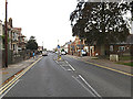
1
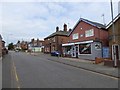
Inn and shops, Military Road Colchester
The Royal Mortar is one of several inns with military names; next door is a grocery shop and tattoo parlour
Image: © David Smith
Taken: 31 May 2017
0.06 miles
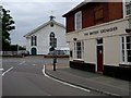
3
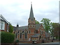
Methodist Church on Wimpole Road, Colchester
Image: © JThomas
Taken: 27 Apr 2017
0.07 miles
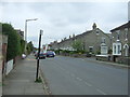
4
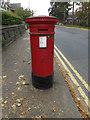
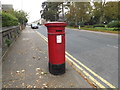
Wimpole Road Victorian Postbox
On Wimpole Road at the junction with Old Heath & Military Road
Postbox No.CO1 24
(Close up)
Image: © Geographer
Taken: 3 Oct 2015
0.07 miles
5
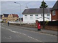
Wimpole Road, Old Heath
At the junction with Old Heath & Military Road
Image: © Geographer
Taken: 3 Oct 2015
0.08 miles
6
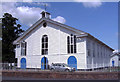
St John's Orthodox Church Colchester Essex
Situated in Military Road.
Image: © Peter Stack
Taken: 14 Jun 2009
0.08 miles
7
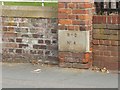
WD boundary marker by St John's Orthodox Church, Colchester
Located in the view Image]
Image: © David Smith
Taken: 31 May 2017
0.08 miles
8
Hunger & Thirst After Righteousness?
The Garrison Church Colchester was built in 1856 as a hospital. Florence Nightingale took one look and declared it as “unsuitable” for a Hospital so it was decided that souls should be healed there. The listed church will have to find a new use according to the Army when the Barracks move to Beerchurch Rd (See Image). The British Grenadier is an honest un-mucked about good old British “Local” it would be a crying shame if the “theme pub” designers ever got their hands on it! Good beer and good company are what really matters. For an update on the Camp Church see
Image
Image: © Glyn Baker
Taken: 13 Aug 2005
0.09 miles
9
St John's Orthodox Church, Colchester
Formerly the garrison church. On the wall by the pillar box is a WD boundary marker Image]
Image: © David Smith
Taken: 31 May 2017
0.09 miles
10
Wimpole Road Victorian Postbox
On Wimpole Road at the junction with Old Heath & Military Road
Postbox No.CO1 24
Image: © Geographer
Taken: 3 Oct 2015
0.09 miles