IMAGES TAKEN NEAR TO
Wix Road, HARWICH, CO12 5LZ
Introduction
This page details the photographs taken nearby to Wix Road, CO12 5LZ by members of the Geograph project.
The Geograph project started in 2005 with the aim of publishing, organising and preserving representative images for every square kilometre of Great Britain, Ireland and the Isle of Man.

There are currently over 7.5m images from over14,400 individuals and you can help contribute to the project by visiting https://www.geograph.org.uk
Image Map (Loading...)


Getting Data...Please wait
Leaflet Map data © OpenStreetMap
Images are licensed for reuse under creativecommons.org/licenses/by-sa/2.0
Notes
- Clicking on the map will re-center to the selected point.
- The higher the marker number, the further away the image location is from the centre of the postcode.
Image Listing (4 Images Found)
Images are licensed for reuse under creativecommons.org/licenses/by-sa/2.0
Image
Details
Distance
1
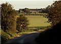
View of Roydon Hall Farm from Primrose Lane
Image: © Robert Edwards
Taken: 6 Nov 2006
0.10 miles
2
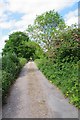
The Drive to Roydon Hall
This does not appear to be a right of way
Image: © Glyn Baker
Taken: 19 May 2020
0.18 miles
3
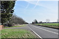
A120 looking east
The Harwich Road at Ramsey Hill.
Image: © MJ Reilly
Taken: 11 Mar 2009
0.19 miles
4
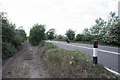
Old A120
This bypassed bit of tarmac was a relief to ride on even with Covid-19 levels of traffic Cycling along the A120 felt somewhat dodgy.
Image: © Glyn Baker
Taken: 19 May 2020
0.23 miles