IMAGES TAKEN NEAR TO
Pelham Close, HARWICH, CO12 4UR
Introduction
This page details the photographs taken nearby to Pelham Close, CO12 4UR by members of the Geograph project.
The Geograph project started in 2005 with the aim of publishing, organising and preserving representative images for every square kilometre of Great Britain, Ireland and the Isle of Man.

There are currently over 7.5m images from over14,400 individuals and you can help contribute to the project by visiting https://www.geograph.org.uk
Image Map
Images are licensed for reuse under creativecommons.org/licenses/by-sa/2.0
Notes
- Clicking on the map will re-center to the selected point.
- The higher the marker number, the further away the image location is from the centre of the postcode.
Image Listing (4 Images Found)
Images are licensed for reuse under creativecommons.org/licenses/by-sa/2.0
Image
Details
Distance
1
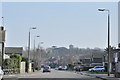
Long Meadows, Dovercourt
Looking NE towards the tower on Fronks Road.
Image: © MJ Reilly
Taken: 11 Mar 2009
0.12 miles
2
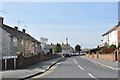
Junction of Willow Way and Lauel Avenue
Looking east down Willow Way on a clear Spring morning.
Image: © MJ Reilly
Taken: 11 Mar 2009
0.17 miles
3
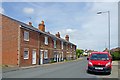
Victorian Terrace on Main Rd
With a Royal Mail Van too.
Image: © Glyn Baker
Taken: 3 Jul 2020
0.24 miles
4
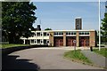
Dovercourt fire station
Dovercourt fire station, Fronks Road, Harwich, Essex
Image: © Kevin Hale
Taken: 5 Jun 2010
0.24 miles