IMAGES TAKEN NEAR TO
Devon Way, HARWICH, CO12 4RA
Introduction
This page details the photographs taken nearby to Devon Way, CO12 4RA by members of the Geograph project.
The Geograph project started in 2005 with the aim of publishing, organising and preserving representative images for every square kilometre of Great Britain, Ireland and the Isle of Man.

There are currently over 7.5m images from over14,400 individuals and you can help contribute to the project by visiting https://www.geograph.org.uk
Image Map
Images are licensed for reuse under creativecommons.org/licenses/by-sa/2.0
Notes
- Clicking on the map will re-center to the selected point.
- The higher the marker number, the further away the image location is from the centre of the postcode.
Image Listing (8 Images Found)
Images are licensed for reuse under creativecommons.org/licenses/by-sa/2.0
Image
Details
Distance

2
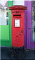
George V postbox on Main Road, Dovercourt
Outside the Post Office.
Postbox No. CO12 58.
See for Image]context.
Image: © JThomas
Taken: 26 Apr 2017
0.15 miles
3
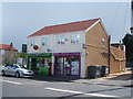
Post Office on Main Road, Dovercourt
Showing position of Postbox No. CO12 58.
See Image] for postbox.
Image: © JThomas
Taken: 26 Apr 2017
0.15 miles
6
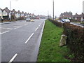
Harwich 3
Old milepost on the B1352 near to Ramsey, Essex. For close up view see http://www.geograph.org.uk/photo/1716136 For more info see http://milestones.megalithia.com/sites/tm225306.htm do look at their home page.
Image: © Keith Evans
Taken: 18 Feb 2010
0.17 miles
7
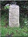
Old Milepost
Old milepost on the B1352 near to Ramsey, Essex. For overall view see http://www.geograph.org.uk/photo/1716143 For more info see http://milestones.megalithia.com/sites/tm225306.htm do look at their home page.
Image: © Keith Evans
Taken: 18 Feb 2010
0.18 miles
8
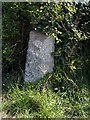
Old Milestone by the B1352, Ramsey Road, Harwich parish
Stone post (plate lost) by the B1352, in parish of HARWICH (TENDRING District), Ramsey Road, opposite No. 100, Upper Dovercourt, set in hedge, on South side of main road. Erected by the Essex Second District turnpike trust in the 19th century.
Inscription once read:-
: (Colchester / 18) : : (Harwich 3) :
Milestone Society National ID: EX_COHH69.
Image: © JV Nicholls
Taken: Unknown
0.19 miles