IMAGES TAKEN NEAR TO
Sweden Close, HARWICH, CO12 4JU
Introduction
This page details the photographs taken nearby to Sweden Close, CO12 4JU by members of the Geograph project.
The Geograph project started in 2005 with the aim of publishing, organising and preserving representative images for every square kilometre of Great Britain, Ireland and the Isle of Man.

There are currently over 7.5m images from over14,400 individuals and you can help contribute to the project by visiting https://www.geograph.org.uk
Image Map
Images are licensed for reuse under creativecommons.org/licenses/by-sa/2.0
Notes
- Clicking on the map will re-center to the selected point.
- The higher the marker number, the further away the image location is from the centre of the postcode.
Image Listing (8 Images Found)
Images are licensed for reuse under creativecommons.org/licenses/by-sa/2.0
Image
Details
Distance
1
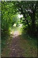
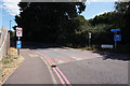
Footpath PROW 169_3
This path runs 967m between Parkeston Road and Main Rd
Image: © Glyn Baker
Taken: 3 Jul 2020
0.05 miles
2
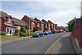
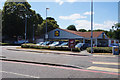
Briardale Ave Harwich
Modern housing on the side of the Ramsey Creek/Dovercourt River valley
Image: © Glyn Baker
Taken: 3 Jul 2020
0.07 miles
6
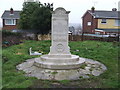
The Grave Of Charles Algernon Fryatt
The grave of Charles Algernon Fryatt at All Saints' church, Dovercourt, Essex. He was master of the Great Eastern Steam Ship Brussels that attempted to ram a German U-boat in 1915 and he was later executed by the Germans although he was a civilian.
Image: © Keith Evans
Taken: 18 Feb 2010
0.23 miles
8
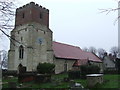
All Saints Dovercourt
The church of All Saints', Dovercourt, Essex.
Image: © Keith Evans
Taken: 18 Feb 2010
0.25 miles