IMAGES TAKEN NEAR TO
Williamsburg Avenue, HARWICH, CO12 4FE
Introduction
This page details the photographs taken nearby to Williamsburg Avenue, CO12 4FE by members of the Geograph project.
The Geograph project started in 2005 with the aim of publishing, organising and preserving representative images for every square kilometre of Great Britain, Ireland and the Isle of Man.

There are currently over 7.5m images from over14,400 individuals and you can help contribute to the project by visiting https://www.geograph.org.uk
Image Map
Images are licensed for reuse under creativecommons.org/licenses/by-sa/2.0
Notes
- Clicking on the map will re-center to the selected point.
- The higher the marker number, the further away the image location is from the centre of the postcode.
Image Listing (22 Images Found)
Images are licensed for reuse under creativecommons.org/licenses/by-sa/2.0
Image
Details
Distance

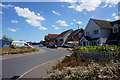
4
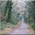
Footpath near Parkeston Cemetery, Harwich
Image: © Roger Jones
Taken: 12 Feb 2023
0.03 miles

6
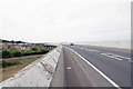
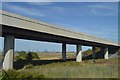
A120 Phoenix Bridge
I bet in normal times the A120 would not be this quiet. The people who move into the houses being built below this bridge are never going to have a quiet life once the traffic returns.
Image: © Glyn Baker
Taken: 2 Jun 2020
0.09 miles
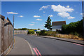
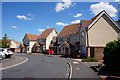
7
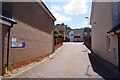
Jamestown Close off Williamsburg Avenue, Harwich
Image: © Ian S
Taken: 28 Jul 2018
0.09 miles