IMAGES TAKEN NEAR TO
Main Road, HARWICH, CO12 3PJ
Introduction
This page details the photographs taken nearby to Main Road, CO12 3PJ by members of the Geograph project.
The Geograph project started in 2005 with the aim of publishing, organising and preserving representative images for every square kilometre of Great Britain, Ireland and the Isle of Man.

There are currently over 7.5m images from over14,400 individuals and you can help contribute to the project by visiting https://www.geograph.org.uk
Image Map (Loading...)


Getting Data...Please wait
Leaflet Map data © OpenStreetMap
Images are licensed for reuse under creativecommons.org/licenses/by-sa/2.0
Notes
- Clicking on the map will re-center to the selected point.
- The higher the marker number, the further away the image location is from the centre of the postcode.
Image Listing (109 Images Found)
Images are licensed for reuse under creativecommons.org/licenses/by-sa/2.0
Image
Details
Distance
1
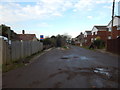
Pattrick's Lane
A dead end dirt track off Main Road. The side road/track on the right is Puddock Close.
Image: © Hamish Griffin
Taken: 20 Jan 2015
0.01 miles
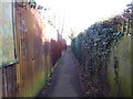
2
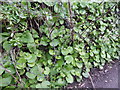
Plants on Patrick's Lane
Not sure what plant they are.
Image: © Hamish Griffin
Taken: 20 Jan 2015
0.02 miles

7
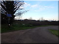
Junction on Pattrick's Lane
The turning on the left is a cycle path.
Image: © Hamish Griffin
Taken: 20 Jan 2015
0.10 miles
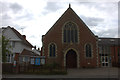
8
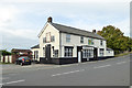
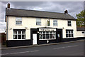
The Royal Oak, Main Road
Across the road from Harwich and Parkeston FC.
Image: © Robin Webster
Taken: 8 Sep 2018
0.10 miles
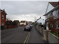
10
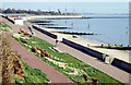
Path in Harwich
Somewhere in Harwich, if you know where, please add.
Image: © Hamish Griffin
Taken: 20 Jan 2015
0.11 miles