IMAGES TAKEN NEAR TO
Barrack Lane, HARWICH, CO12 3NP
Introduction
This page details the photographs taken nearby to Barrack Lane, CO12 3NP by members of the Geograph project.
The Geograph project started in 2005 with the aim of publishing, organising and preserving representative images for every square kilometre of Great Britain, Ireland and the Isle of Man.

There are currently over 7.5m images from over14,400 individuals and you can help contribute to the project by visiting https://www.geograph.org.uk
Image Map
Images are licensed for reuse under creativecommons.org/licenses/by-sa/2.0
Notes
- Clicking on the map will re-center to the selected point.
- The higher the marker number, the further away the image location is from the centre of the postcode.
Image Listing (115 Images Found)
Images are licensed for reuse under creativecommons.org/licenses/by-sa/2.0
Image
Details
Distance
6
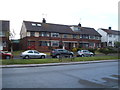
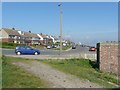
A gift from Norway
These houses were a gift from Norway after the 1953 floods Harwich Essex. See http://www.geograph.org.uk/photo/729277 for more info.
Image: © Keith Evans
Taken: 1 Aug 2005
0.10 miles
8
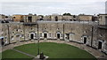
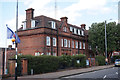
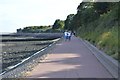
The Redoubt Fort, Harwich
This fort was built to defend Harwich during the Napoleonic Wars, but never fired a shot in anger.
Image: © John Welford
Taken: 29 Sep 2013
0.11 miles
9
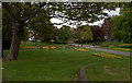
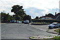
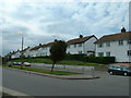
Green at junction of Barrack Lane and Main Road
Image: © Robert Eva
Taken: 27 Apr 2017
0.11 miles