IMAGES TAKEN NEAR TO
North Hill, COLCHESTER, CO1 1QF
Introduction
This page details the photographs taken nearby to North Hill, CO1 1QF by members of the Geograph project.
The Geograph project started in 2005 with the aim of publishing, organising and preserving representative images for every square kilometre of Great Britain, Ireland and the Isle of Man.

There are currently over 7.5m images from over14,400 individuals and you can help contribute to the project by visiting https://www.geograph.org.uk
Image Map
Images are licensed for reuse under creativecommons.org/licenses/by-sa/2.0
Notes
- Clicking on the map will re-center to the selected point.
- The higher the marker number, the further away the image location is from the centre of the postcode.
Image Listing (286 Images Found)
Images are licensed for reuse under creativecommons.org/licenses/by-sa/2.0
Image
Details
Distance


3
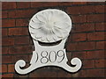
Date stone on the Georgian houses in North Hill, CO1
See Image
Image: © Mike Quinn
Taken: 2 Apr 2014
0.02 miles
4
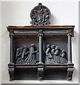
St Peter, Colchester, Essex - Wall monument
Image: © John Salmon
Taken: 14 May 2010
0.03 miles
5
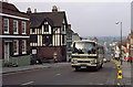
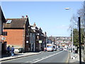
North Hill
A Norfolk's service from Nayland climbs the hill towards Colchester city centre. The vehicle, NPV 444W,is a Volvo B58 with Plaxton Supreme bodywork. The cones are probably out in preparation for an army remembrance parade. The junction at Middleborough is visible at the bottom of the hill.
Image: © Martin Addison
Taken: Unknown
0.03 miles
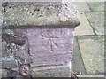
6
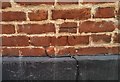
Ordnance Survey Cut Mark
This OS cut mark can be found on No9 North Hill. It marks a point 23.156m above mean sea level.
Image: © Adrian Dust
Taken: 8 Jan 2020
0.03 miles
8
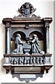
St Peter, Colchester, Essex - Wall monument
Image: © John Salmon
Taken: 14 May 2010
0.03 miles
9
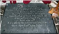
St Peter, Colchester, Essex - Ledger slab
Image: © John Salmon
Taken: 14 May 2010
0.03 miles
10
Ordnance Survey Cut Mark
This OS cut mark can be found on the NW angle of St Peter's Church. It marks a point 30.782m above mean sea level.
Image: © Adrian Dust
Taken: 7 Jan 2020
0.03 miles