IMAGES TAKEN NEAR TO
Pavilion View, COLCHESTER, CO1 1GD
Introduction
This page details the photographs taken nearby to Pavilion View, CO1 1GD by members of the Geograph project.
The Geograph project started in 2005 with the aim of publishing, organising and preserving representative images for every square kilometre of Great Britain, Ireland and the Isle of Man.

There are currently over 7.5m images from over14,400 individuals and you can help contribute to the project by visiting https://www.geograph.org.uk
Image Map
Images are licensed for reuse under creativecommons.org/licenses/by-sa/2.0
Notes
- Clicking on the map will re-center to the selected point.
- The higher the marker number, the further away the image location is from the centre of the postcode.
Image Listing (39 Images Found)
Images are licensed for reuse under creativecommons.org/licenses/by-sa/2.0
Image
Details
Distance
1
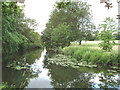
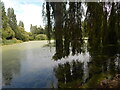
River Colne, Colchester
The cricket ground on the right is used for Essex county matches.
Image: © David Hawgood
Taken: 15 Jun 2006
0.09 miles
2
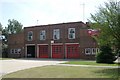
Colchester fire station
Colchester fire station, Cowdray Avenue, Colchester, Essex
Image: © Kevin Hale
Taken: 5 Jun 2010
0.10 miles
3
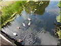
Swans in the River Colne
I'm not sure I've got the correct bridge, it might be the one to the west.
Image: © Hamish Griffin
Taken: 1 Aug 2020
0.13 miles
4
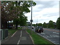
Cycle path beside Cowdray Avenue, Colchester
Looking east.
Image: © JThomas
Taken: 24 Apr 2017
0.13 miles
6
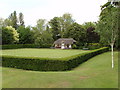
Bowling green, Castle Park, Colchester
The River Colne is just beyond the green.
Image: © David Hawgood
Taken: 15 Jun 2006
0.14 miles
7
Middlebrough Mill Site
The site of the Middlebrough Mill on the River Colne in the Lower Castle Park.
Image: © Glyn Baker
Taken: 12 Aug 2009
0.16 miles
8
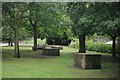
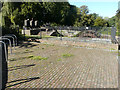
Tank Traps
These tank traps are in the Lower Castle Park
Image: © Glyn Baker
Taken: 12 Aug 2009
0.16 miles
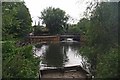
9
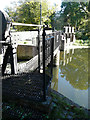
Middle Mill Weir, River Colne
Showing the sluice gates, which were manufactured by an engineering company called Riches and Watts in 1875 http://www.waymarking.com/waymarks/WMPTJH_Middle_Mill_Weir_River_Colne_Colchester_UK whose details are on an embossed plate just beyond the further brick pier.
Image: © John Baker
Taken: 26 Sep 2018
0.17 miles
10
Middle Mill Weir, River Colne
Showing the sluice gear, which was manufactured by an engineering company called Riches and Watts in 1875 http://www.waymarking.com/waymarks/WMPTJH_Middle_Mill_Weir_River_Colne_Colchester_UK
Image: © John Baker
Taken: 26 Sep 2018
0.17 miles