IMAGES TAKEN NEAR TO
St. Peters Street, COLCHESTER, CO1 1BQ
Introduction
This page details the photographs taken nearby to St. Peters Street, CO1 1BQ by members of the Geograph project.
The Geograph project started in 2005 with the aim of publishing, organising and preserving representative images for every square kilometre of Great Britain, Ireland and the Isle of Man.

There are currently over 7.5m images from over14,400 individuals and you can help contribute to the project by visiting https://www.geograph.org.uk
Image Map
Images are licensed for reuse under creativecommons.org/licenses/by-sa/2.0
Notes
- Clicking on the map will re-center to the selected point.
- The higher the marker number, the further away the image location is from the centre of the postcode.
Image Listing (243 Images Found)
Images are licensed for reuse under creativecommons.org/licenses/by-sa/2.0
Image
Details
Distance
1
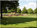
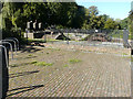
Children's playground, Colchester
In a park north of the River Colne, viewed from the riverside walk.
Image: © David Hawgood
Taken: 15 Jun 2006
0.01 miles
2
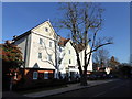
Premier Inn, St Peters Street, Colchester
Image: © PAUL FARMER
Taken: 22 Nov 2017
0.05 miles
3
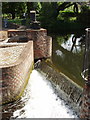
Mill weir, Colchester
There has been a mill here on the River Colne since the time of the Norman Conquest.
Image: © David Hawgood
Taken: 15 Jun 2006
0.07 miles
4
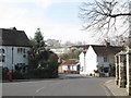
St. Peter's Street / Middle Mill, CO1
Shows the location of Image
Image: © Mike Quinn
Taken: 2 Apr 2014
0.07 miles
5
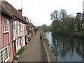
Cottages and the River Colne downstream of North Bridge
Image: © Mike Quinn
Taken: 2 Apr 2014
0.07 miles
6
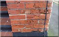
Ordnance Survey Cut Mark
This OS cut mark can be found on No32 North Gate Street. It marks a point 10.958m above mean sea level.
Image: © Adrian Dust
Taken: 8 Jan 2020
0.08 miles
7
Middle Mill Weir, River Colne
Showing the sluice gear, which was manufactured by an engineering company called Riches and Watts in 1875 http://www.waymarking.com/waymarks/WMPTJH_Middle_Mill_Weir_River_Colne_Colchester_UK
Image: © John Baker
Taken: 26 Sep 2018
0.08 miles
8
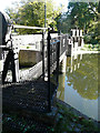
Middle Mill Weir, River Colne
Showing the sluice gates, which were manufactured by an engineering company called Riches and Watts in 1875 http://www.waymarking.com/waymarks/WMPTJH_Middle_Mill_Weir_River_Colne_Colchester_UK whose details are on an embossed plate just beyond the further brick pier.
Image: © John Baker
Taken: 26 Sep 2018
0.08 miles
9
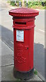
Edward VII postbox, St. Peter's Street / Middle Mill, CO1
Image: © Mike Quinn
Taken: 2 Apr 2014
0.08 miles
10
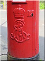
Edward VII postbox, St. Peter's Street / Middle Mill, CO1 - royal cipher
See Image
Image: © Mike Quinn
Taken: 2 Apr 2014
0.08 miles