IMAGES TAKEN NEAR TO
Heath Road, MANNINGTREE, CO11 2XJ
Introduction
This page details the photographs taken nearby to Heath Road, CO11 2XJ by members of the Geograph project.
The Geograph project started in 2005 with the aim of publishing, organising and preserving representative images for every square kilometre of Great Britain, Ireland and the Isle of Man.

There are currently over 7.5m images from over14,400 individuals and you can help contribute to the project by visiting https://www.geograph.org.uk
Image Map
Images are licensed for reuse under creativecommons.org/licenses/by-sa/2.0
Notes
- Clicking on the map will re-center to the selected point.
- The higher the marker number, the further away the image location is from the centre of the postcode.
Image Listing (7 Images Found)
Images are licensed for reuse under creativecommons.org/licenses/by-sa/2.0
Image
Details
Distance
1
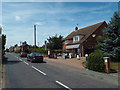
Bradfield Heath Post Office
The village post office in Bradfield Heath, in north Essex.
Image: © Malc McDonald
Taken: 18 Jul 2015
0.06 miles
2
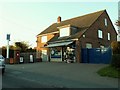
Post Office and village store at Bradfield Heath, Essex
Image: © Robert Edwards
Taken: 6 Nov 2006
0.07 miles
3
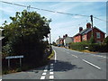
Windmill Road, Bradfield Heath
Windmill Road in the village of Bradfield Heath, in north Essex.
Image: © Malc McDonald
Taken: 18 Jul 2015
0.08 miles
4
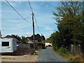
Steam Mill Road, Bradfield Heath
Steam Mill Road in the village of Bradfield Heath.
Image: © Malc McDonald
Taken: 18 Jul 2015
0.08 miles
5
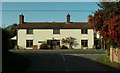
House in Bradfield Heath, Essex
This attractive house stands at the end of Dairyhouse Lane, where it meets the main road through Bradfield Heath.
Image: © Robert Edwards
Taken: 6 Nov 2006
0.21 miles
6
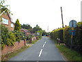
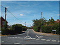
Dairyhouse Lane, Bradfield Heath
The square blue sign indicates that Dairyhouse Lane is a no through road.
Image: © Malc McDonald
Taken: 18 Jul 2015
0.24 miles