IMAGES TAKEN NEAR TO
Station Road, MANNINGTREE, CO11 2UP
Introduction
This page details the photographs taken nearby to Station Road, CO11 2UP by members of the Geograph project.
The Geograph project started in 2005 with the aim of publishing, organising and preserving representative images for every square kilometre of Great Britain, Ireland and the Isle of Man.

There are currently over 7.5m images from over14,400 individuals and you can help contribute to the project by visiting https://www.geograph.org.uk
Image Map
Images are licensed for reuse under creativecommons.org/licenses/by-sa/2.0
Notes
- Clicking on the map will re-center to the selected point.
- The higher the marker number, the further away the image location is from the centre of the postcode.
Image Listing (39 Images Found)
Images are licensed for reuse under creativecommons.org/licenses/by-sa/2.0
Image
Details
Distance
1
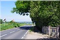
Ship Hill at Stour Lodge
Looking back towards Mistley
Image: © Glyn Baker
Taken: 19 May 2020
0.04 miles
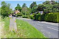
2
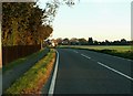
The B.1352 at Bradfield
This section of the road is known as Ship Hill.
Image: © Robert Edwards
Taken: 6 Nov 2006
0.07 miles

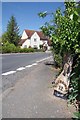
5
B&B Sign at Elmsworth House
Looking along the B1352
Image: © Glyn Baker
Taken: 19 May 2020
0.12 miles
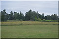
6
Bradfield Triangulation Pillar
On the B1352 Station Rd
Image: © Glyn Baker
Taken: 19 May 2020
0.13 miles
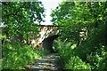
7
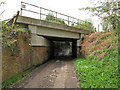
Rail bridge over byway
This is bridge number 1055, 62m, 46ch from Liverpool Street on the Great Eastern line to Harwich.
The byway is Ship Lane leading from the B1352 Station Road towards the River Stour.
Image: © Roger Jones
Taken: 7 May 2012
0.17 miles
9
Station Road, 12 Miles to Colchester
An old iron mile post on the B1035
Image: © Glyn Baker
Taken: 19 May 2020
0.19 miles
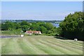
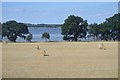
10
Railway Bridge Over Shore Lane
Looking towards the river.
Image: © Glyn Baker
Taken: 19 May 2020
0.19 miles