IMAGES TAKEN NEAR TO
Bradfield Road, MANNINGTREE, CO11 2SP
Introduction
This page details the photographs taken nearby to Bradfield Road, CO11 2SP by members of the Geograph project.
The Geograph project started in 2005 with the aim of publishing, organising and preserving representative images for every square kilometre of Great Britain, Ireland and the Isle of Man.

There are currently over 7.5m images from over14,400 individuals and you can help contribute to the project by visiting https://www.geograph.org.uk
Image Map
Images are licensed for reuse under creativecommons.org/licenses/by-sa/2.0
Notes
- Clicking on the map will re-center to the selected point.
- The higher the marker number, the further away the image location is from the centre of the postcode.
Image Listing (14 Images Found)
Images are licensed for reuse under creativecommons.org/licenses/by-sa/2.0
Image
Details
Distance
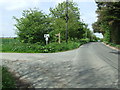
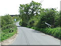
2
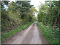
Bradfield Road, near Bradfield
Bradfield Road is a country lane leading from Bradfield to Wix, in north Essex.
Image: © Malc McDonald
Taken: 18 Jul 2015
0.04 miles
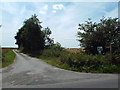
3
Road to Bluehouse Farm
Looking north east from Bradfield Road.
Image: © JThomas
Taken: 26 Apr 2017
0.05 miles
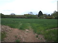
4
Footpath Sign And Track
Footpath and track off Bradfield Road Wix, Essex leading to Dairy House.
Image: © Keith Evans
Taken: 10 May 2015
0.05 miles
5
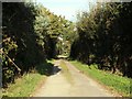
Track to Dairyhouse Farm, near Bradfield
This track, which leads to Dairyhouse Farm, is a public right of way for people on foot. The public footpath sign is just visible to the right of the image.
Image: © Malc McDonald
Taken: 18 Jul 2015
0.06 miles
6
Track to Bluehouse Farm, near Wix
Not much has changed since a similar image was taken in November 2006 Image
Image: © Malc McDonald
Taken: 18 Jul 2015
0.07 miles
7
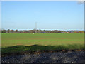
Crop field near Pond Hall
Off Bradfield Road.
Image: © JThomas
Taken: 26 Apr 2017
0.07 miles
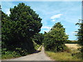
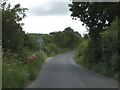
8
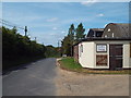
Wix Road
Wix Road near to Bradfield, Essex.
Image: © Keith Evans
Taken: 10 May 2015
0.15 miles
9
Small bridge on road from Bradfield to Wix
A minor stream (not named on OS map) runs under this bridge to join the Stour near Wrabness
Image: © David Smith
Taken: 16 Jun 2014
0.16 miles