IMAGES TAKEN NEAR TO
Paynes Lane, MANNINGTREE, CO11 2PJ
Introduction
This page details the photographs taken nearby to Paynes Lane, CO11 2PJ by members of the Geograph project.
The Geograph project started in 2005 with the aim of publishing, organising and preserving representative images for every square kilometre of Great Britain, Ireland and the Isle of Man.

There are currently over 7.5m images from over14,400 individuals and you can help contribute to the project by visiting https://www.geograph.org.uk
Image Map
Images are licensed for reuse under creativecommons.org/licenses/by-sa/2.0
Notes
- Clicking on the map will re-center to the selected point.
- The higher the marker number, the further away the image location is from the centre of the postcode.
Image Listing (5 Images Found)
Images are licensed for reuse under creativecommons.org/licenses/by-sa/2.0
Image
Details
Distance
1
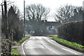
Bentley Road, Little Bromley
Looking south to the Paynes Lane junction.
Image: © MJ Reilly
Taken: 11 Mar 2009
0.18 miles
3
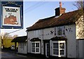
The Fox and Hounds
Fortunately the Hunting Act 2004 http://www.opsi.gov.uk/acts/acts2004/20040037.htm did not create an offence of "glorification of hunting" otherwise this pub in Bentley Road, Little Bromley might be in trouble.
Image: © Roger W Haworth
Taken: 15 Feb 2006
0.22 miles
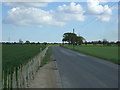
4
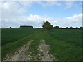
Crop field near Mulley's Farm
Off Bentley Road.
Image: © JThomas
Taken: 25 Apr 2017
0.23 miles
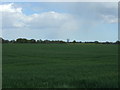
5
Mulberry Lane
Track off Bentley Road near Mulley's Farm.
Image: © JThomas
Taken: 25 Apr 2017
0.24 miles