IMAGES TAKEN NEAR TO
Wignall Street, MANNINGTREE, CO11 2JJ
Introduction
This page details the photographs taken nearby to Wignall Street, CO11 2JJ by members of the Geograph project.
The Geograph project started in 2005 with the aim of publishing, organising and preserving representative images for every square kilometre of Great Britain, Ireland and the Isle of Man.

There are currently over 7.5m images from over14,400 individuals and you can help contribute to the project by visiting https://www.geograph.org.uk
Image Map
Images are licensed for reuse under creativecommons.org/licenses/by-sa/2.0
Notes
- Clicking on the map will re-center to the selected point.
- The higher the marker number, the further away the image location is from the centre of the postcode.
Image Listing (13 Images Found)
Images are licensed for reuse under creativecommons.org/licenses/by-sa/2.0
Image
Details
Distance
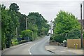
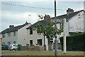
2
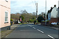
A137 Wignall Street
The western outskirts of Lawford.
Image: © Robin Webster
Taken: 9 Feb 2019
0.08 miles

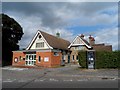
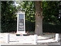
5

Not the Kings Arms, Lawford
A few years ago this was a pub, although at over £4 a pint I'm hardly surprised so many have gone.
Image: © David Howard
Taken: 23 Feb 2019
0.12 miles