IMAGES TAKEN NEAR TO
Harvey Close, MANNINGTREE, CO11 2HW
Introduction
This page details the photographs taken nearby to Harvey Close, CO11 2HW by members of the Geograph project.
The Geograph project started in 2005 with the aim of publishing, organising and preserving representative images for every square kilometre of Great Britain, Ireland and the Isle of Man.

There are currently over 7.5m images from over14,400 individuals and you can help contribute to the project by visiting https://www.geograph.org.uk
Image Map
Images are licensed for reuse under creativecommons.org/licenses/by-sa/2.0
Notes
- Clicking on the map will re-center to the selected point.
- The higher the marker number, the further away the image location is from the centre of the postcode.
Image Listing (39 Images Found)
Images are licensed for reuse under creativecommons.org/licenses/by-sa/2.0
Image
Details
Distance
3
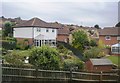
The Essex Way footpath entering Lawford
A new housing estate on the left, and Highfields County Primary School on the right.
Image: © Tim Heaton
Taken: 16 Oct 2020
0.11 miles
7
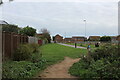
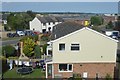
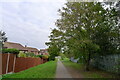
Essex Way in Lawford
The long distance footpath skirts a housing estate in Lawford, passing a school to reach Mill Hill - and on into Manningtree.
Image: © Chris Heaton
Taken: 16 Oct 2020
0.14 miles
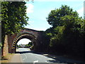
8
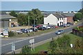
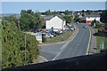
B1352 Station Road, Lawford
Approaching Arch Bridge at the junction with Causeway End
Image: © Geographer
Taken: 17 Aug 2018
0.15 miles
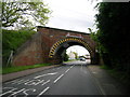
10
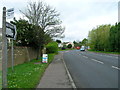
Bridge across Station Road, Manningtree
This arch bridge carries the Harwich branch line across Station Road in Manningtree.
The road markings guide drivers of tall vehicles to use the centre of the road.
Image: © Malc McDonald
Taken: 18 Jul 2015
0.15 miles