IMAGES TAKEN NEAR TO
Bergholt Road, MANNINGTREE, CO11 1RD
Introduction
This page details the photographs taken nearby to Bergholt Road, CO11 1RD by members of the Geograph project.
The Geograph project started in 2005 with the aim of publishing, organising and preserving representative images for every square kilometre of Great Britain, Ireland and the Isle of Man.

There are currently over 7.5m images from over14,400 individuals and you can help contribute to the project by visiting https://www.geograph.org.uk
Image Map
Images are licensed for reuse under creativecommons.org/licenses/by-sa/2.0
Notes
- Clicking on the map will re-center to the selected point.
- The higher the marker number, the further away the image location is from the centre of the postcode.
Image Listing (6 Images Found)
Images are licensed for reuse under creativecommons.org/licenses/by-sa/2.0
Image
Details
Distance

3
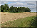
Looking towards a small wood from Dazeley's Lane
Image: © Roger Jones
Taken: 30 Jul 2011
0.18 miles
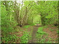
6
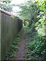
Footpath
Footpath near to Cattawade, Suffolk.
Image: © Keith Evans
Taken: 17 Oct 2013
0.25 miles