IMAGES TAKEN NEAR TO
The Chase, MANNINGTREE, CO11 1PT
Introduction
This page details the photographs taken nearby to The Chase, CO11 1PT by members of the Geograph project.
The Geograph project started in 2005 with the aim of publishing, organising and preserving representative images for every square kilometre of Great Britain, Ireland and the Isle of Man.

There are currently over 7.5m images from over14,400 individuals and you can help contribute to the project by visiting https://www.geograph.org.uk
Image Map
Images are licensed for reuse under creativecommons.org/licenses/by-sa/2.0
Notes
- Clicking on the map will re-center to the selected point.
- The higher the marker number, the further away the image location is from the centre of the postcode.
Image Listing (6 Images Found)
Images are licensed for reuse under creativecommons.org/licenses/by-sa/2.0
Image
Details
Distance
1
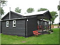
Bunkhouse
This extremely well equipped YHA bunkhouse opened in 2008.
Image: © Steve Gardiner
Taken: 22 Jul 2008
0.04 miles
2
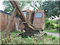
Rusting dinosaur
This and other old plant was clearly left as decorative enhancements to the farm. I stayed at the nearby YHA bunkhouse in 2008 and 09 where I was able to explore some of the farm.
Image: © Steve Gardiner
Taken: 22 Jul 2008
0.06 miles
3
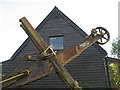
Rust against wood
Here's more rusted machinery - with a farm building behind.
Image: © Steve Gardiner
Taken: 22 Jul 2008
0.07 miles
4
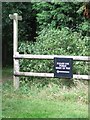
We Always Do
Sign seen near to Cattawade Suffolk.
Image: © Keith Evans
Taken: 22 Jul 2007
0.11 miles
5
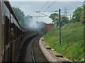
The bridge over the railway line
On the Easterling train to London
Image: © Ashley Dace
Taken: 16 May 2009
0.13 miles
6
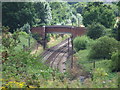
Railway Bridge
Railway bridge for access to Brantham Hall farm near to Brantham Suffolk.
Image: © Keith Evans
Taken: 22 Jul 2007
0.14 miles