IMAGES TAKEN NEAR TO
Brooks Malting, Kiln Lane, MANNINGTREE, CO11 1HP
Introduction
This page details the photographs taken nearby to Brooks Malting, Kiln Lane, CO11 1HP by members of the Geograph project.
The Geograph project started in 2005 with the aim of publishing, organising and preserving representative images for every square kilometre of Great Britain, Ireland and the Isle of Man.

There are currently over 7.5m images from over14,400 individuals and you can help contribute to the project by visiting https://www.geograph.org.uk
Image Map
Images are licensed for reuse under creativecommons.org/licenses/by-sa/2.0
Notes
- Clicking on the map will re-center to the selected point.
- The higher the marker number, the further away the image location is from the centre of the postcode.
Image Listing (149 Images Found)
Images are licensed for reuse under creativecommons.org/licenses/by-sa/2.0
Image
Details
Distance
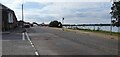
3

Manningtree Stour River And Quay
Looking westwards towards the town.
Image: © Tim Marchant
Taken: 16 Apr 2010
0.02 miles
4

River Stour By Manningtree
View down the river.
Image: © Tim Marchant
Taken: 16 Apr 2010
0.02 miles
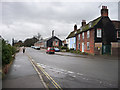
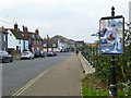
6
The Walls
Kiln Lane can be seen on the left.
Image: © Hamish Griffin
Taken: 28 Oct 2014
0.03 miles
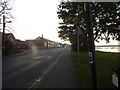
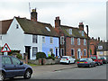
8
The Walls, Manningtree
Along the river bank.
Image: © Robin Webster
Taken: 30 Oct 2016
0.04 miles
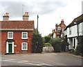
9
1, 3, 4, The Walls, Manningtree
Grade II listed, 18th century.
Image: © Robin Webster
Taken: 30 Oct 2016
0.04 miles
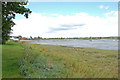
10
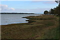
The Estuary below The Walls, Manningtree
The Essex Way long distance footpath follows The Walls from Manningtree towards Mistley.
Image: © Chris Heaton
Taken: 16 Oct 2020
0.05 miles