IMAGES TAKEN NEAR TO
Keeble Road, MANNINGTREE, CO11 1FG
Introduction
This page details the photographs taken nearby to Keeble Road, CO11 1FG by members of the Geograph project.
The Geograph project started in 2005 with the aim of publishing, organising and preserving representative images for every square kilometre of Great Britain, Ireland and the Isle of Man.

There are currently over 7.5m images from over14,400 individuals and you can help contribute to the project by visiting https://www.geograph.org.uk
Image Map (Loading...)


Getting Data...Please wait
Leaflet Map data © OpenStreetMap
Images are licensed for reuse under creativecommons.org/licenses/by-sa/2.0
Notes
- Clicking on the map will re-center to the selected point.
- The higher the marker number, the further away the image location is from the centre of the postcode.
Image Listing (22 Images Found)
Images are licensed for reuse under creativecommons.org/licenses/by-sa/2.0
Image
Details
Distance
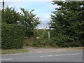
1
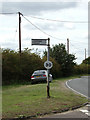
Signpost on Church Lane
At the junction with the A137 Ipswich Road
Image: © Geographer
Taken: 17 Aug 2018
0.09 miles
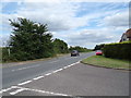
3
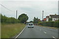
A137 Ipswich Road, Brantham
At the junction with Church Lane
Image: © Geographer
Taken: 17 Aug 2018
0.09 miles
4
Footpath to Brantham Bridge
Off the A137 Ipswich Road at the junction with Church Lane
Image: © Geographer
Taken: 17 Aug 2018
0.09 miles
5
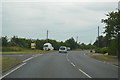
A137 Ipswich Road, Brantham
At the junction with Church Lane
Image: © Geographer
Taken: 17 Aug 2018
0.09 miles
6
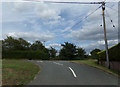
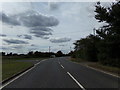
Church Lane, Brantham
At the junction with the A137 Ipswich Road
Image: © Geographer
Taken: 17 Aug 2018
0.09 miles
7
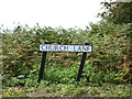
Church Lane sign
On Church Lane at the junction with the A137 Ipswich Road
Image: © Geographer
Taken: 17 Aug 2018
0.10 miles
9
Church Lane, Brantham
At the junction with the A137 Ipswich Road
Image: © Geographer
Taken: 17 Aug 2018
0.10 miles