IMAGES TAKEN NEAR TO
Hall Road, SUDBURY, CO10 9QU
Introduction
This page details the photographs taken nearby to Hall Road, CO10 9QU by members of the Geograph project.
The Geograph project started in 2005 with the aim of publishing, organising and preserving representative images for every square kilometre of Great Britain, Ireland and the Isle of Man.

There are currently over 7.5m images from over14,400 individuals and you can help contribute to the project by visiting https://www.geograph.org.uk
Image Map
Images are licensed for reuse under creativecommons.org/licenses/by-sa/2.0
Notes
- Clicking on the map will re-center to the selected point.
- The higher the marker number, the further away the image location is from the centre of the postcode.
Image Listing (774 Images Found)
Images are licensed for reuse under creativecommons.org/licenses/by-sa/2.0
Image
Details
Distance
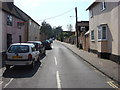
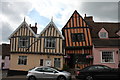
2
Hall Road, Lavenham
Seen from the High Street.
Image: © Stefan Czapski
Taken: 25 Aug 2013
0.03 miles
3
![Lavenham houses [1]](https://s2.geograph.org.uk/geophotos/06/74/71/6747194_011d8673_120x120.jpg)
Lavenham houses [1]
Number 7 Hall Road is a 16th or 17th timber framed and plastered house. There is a rear wing and some modern additions. Listed, grade II, with details at: https://historicengland.org.uk/listing/the-list/list-entry/1351503
Lavenham is a village in Suffolk about 5 miles north east of Sudbury. The village has Saxon origins but is best known as a medieval wool town. Granted a market charter in 1257, the village prospered in the 15th century and many buildings date to that period. The town grew so fast that many of the houses were built in haste with green timber. As the wood dried, the timbers warped causing the houses to bend at unexpected angles. Unfortunately, the good times didn't last long and the cloth industry declined so no one had money to rebuild their homes and Lavenham’s crooked houses were left as they were.
Image: © Michael Dibb
Taken: 13 Sep 2020
0.03 miles
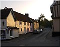
4
Crooked House Gallery, Lavenham
The orange-coloured building is the Crooked House. Viewed from the front it appears to be toppling over.
Image: © Bob Jones
Taken: 27 Jun 2008
0.05 miles
5
Houses on the High Street
The nearest building is No. 6 High Street and dates from the fiteenth century http://www.britishlistedbuildings.co.uk/en-276701-6-high-street-lavenham-suffolk#.VxqNHkfkoeU
Image: © Jonathan Thacker
Taken: 11 Apr 2016
0.05 miles
6
![Lavenham houses [5]](https://s3.geograph.org.uk/geophotos/06/74/71/6747199_92422ef0_120x120.jpg)
Lavenham houses [5]
A 15th century hall house, with crosswings at both ends is now three properties, numbers 7, 8 and 9 High Street. The house is timber framed and plastered and has been greatly altered in the 18th and 19th centuries.
Number 9, seen here, is the north crosswing which was rebuilt in brick in the late 18th century with a hipped roof. The south crosswing is number 7 Image and the hall block is number 8 Image Listed, grade II, with details at: https://historicengland.org.uk/listing/the-list/list-entry/1037201
Lavenham is a village in Suffolk about 5 miles north east of Sudbury. The village has Saxon origins but is best known as a medieval wool town. Granted a market charter in 1257, the village prospered in the 15th century and many buildings date to that period. The town grew so fast that many of the houses were built in haste with green timber. As the wood dried, the timbers warped causing the houses to bend at unexpected angles. Unfortunately, the good times didn't last long and the cloth industry declined so no one had money to rebuild their homes and Lavenham’s crooked houses were left as they were.
Image: © Michael Dibb
Taken: 13 Sep 2020
0.05 miles
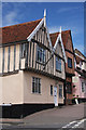
7
6 and 7 High Street, Lavenham
Grade II Listed houses. The twin gable No.6 is a 15th to 16th century timber-framed house. No.7 The Crooked House is in fact the south cross wing of a 15th century hall house much altered in the 18th and 19th century. Previously The Crooked House Gallery from about 1993 it is currently (2017) occupied by Munnings Tearoom, established in 2004 who moved here 2015. Their two websites claim a build date around 1395-1400. The 1840s nursery rhyme about the crooked man, his crooked cat and crooked mouse was supposedly inspired by this building. With the rich fast growing late 15th century town, many houses were built in haste with green timber. As the wood began to dry it started to twist.
Image: © Jo and Steve Turner
Taken: 17 Jun 2017
0.05 miles
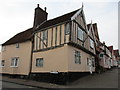
9
![Lavenham houses [2]](https://s0.geograph.org.uk/geophotos/06/74/71/6747196_d5e216e0_120x120.jpg)
Lavenham houses [2]
Number 6 High Street is a 15th or 16th century house with twin gables to the front. Timber framed and plastered, jettied to the front with exposed framing. The house has been restored. Listed, grade II, with details at: https://historicengland.org.uk/listing/the-list/list-entry/1285333
Lavenham is a village in Suffolk about 5 miles north east of Sudbury. The village has Saxon origins but is best known as a medieval wool town. Granted a market charter in 1257, the village prospered in the 15th century and many buildings date to that period. The town grew so fast that many of the houses were built in haste with green timber. As the wood dried, the timbers warped causing the houses to bend at unexpected angles. Unfortunately, the good times didn't last long and the cloth industry declined so no one had money to rebuild their homes and Lavenham’s crooked houses were left as they were.
Image: © Michael Dibb
Taken: 13 Sep 2020
0.05 miles
10
![Lavenham houses [3]](https://s1.geograph.org.uk/geophotos/06/74/71/6747197_5622eca7_120x120.jpg)
Lavenham houses [3]
A 15th century hall house, with crosswings at both ends is now three properties, numbers 7, 8 and 9 High Street. The house is timber framed and plastered and has been greatly altered in the 18th and 19th centuries.
Known as The Crooked House, number 7, seen here, is the south crosswing. The wing is jettied to the street with exposed framing and has been restored. Inside all the framing is exposed. Currently in use as tearooms. The hall block is number 8 Image and the north crosswing is number 9 Image Listed, grade II, with details at: https://historicengland.org.uk/listing/the-list/list-entry/1037201
Lavenham is a village in Suffolk about 5 miles north east of Sudbury. The village has Saxon origins but is best known as a medieval wool town. Granted a market charter in 1257, the village prospered in the 15th century and many buildings date to that period. The town grew so fast that many of the houses were built in haste with green timber. As the wood dried, the timbers warped causing the houses to bend at unexpected angles. Unfortunately, the good times didn't last long and the cloth industry declined so no one had money to rebuild their homes and Lavenham’s crooked houses were left as they were.
Image: © Michael Dibb
Taken: 13 Sep 2020
0.05 miles