IMAGES TAKEN NEAR TO
Preston St. Mary, SUDBURY, CO10 9NJ
Introduction
This page details the photographs taken nearby to CO10 9NJ by members of the Geograph project.
The Geograph project started in 2005 with the aim of publishing, organising and preserving representative images for every square kilometre of Great Britain, Ireland and the Isle of Man.

There are currently over 7.5m images from over14,400 individuals and you can help contribute to the project by visiting https://www.geograph.org.uk
Image Map (Loading...)


Getting Data...Please wait
Leaflet Map data © OpenStreetMap
Images are licensed for reuse under creativecommons.org/licenses/by-sa/2.0
Notes
- Clicking on the map will re-center to the selected point.
- The higher the marker number, the further away the image location is from the centre of the postcode.
Image Listing (6 Images Found)
Images are licensed for reuse under creativecommons.org/licenses/by-sa/2.0
Image
Details
Distance
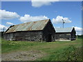
2
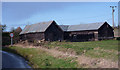
Barns by lane
Wooden barns seen by the lane towards Whelp Street and Preston St Mary from Kettlebaston.
Image: © Andrew Hill
Taken: 28 Nov 2009
0.02 miles
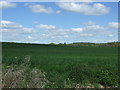
4
Fields north of lane
Fields towards the shallow valley of the infant river Brett west of Kettlebaston.
Image: © Andrew Hill
Taken: 28 Nov 2009
0.06 miles
5
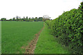
Footpath on field margin, Whelp Street, Preston St Mary
A public footpath on the margin of an arable field, near Whelp Street, Preston St Mary
This photo is featured in the "Lavenham and backroads to Semer" geo-trip here: http://www.geograph.org.uk/geotrips/999
Image: © Roger Jones
Taken: 24 May 2015
0.19 miles
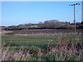
6
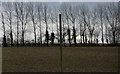
Line of trees across the top of a field
A zoom shot on a rather cloudy early afternoon. The telegraph pole is by the lane.
Image: © Andrew Hill
Taken: 28 Nov 2009
0.20 miles