IMAGES TAKEN NEAR TO
The Street, SUDBURY, CO10 9NF
Introduction
This page details the photographs taken nearby to The Street, CO10 9NF by members of the Geograph project.
The Geograph project started in 2005 with the aim of publishing, organising and preserving representative images for every square kilometre of Great Britain, Ireland and the Isle of Man.

There are currently over 7.5m images from over14,400 individuals and you can help contribute to the project by visiting https://www.geograph.org.uk
Image Map (Loading...)


Getting Data...Please wait
Leaflet Map data © OpenStreetMap
Images are licensed for reuse under creativecommons.org/licenses/by-sa/2.0
Notes
- Clicking on the map will re-center to the selected point.
- The higher the marker number, the further away the image location is from the centre of the postcode.
Image Listing (16 Images Found)
Images are licensed for reuse under creativecommons.org/licenses/by-sa/2.0
Image
Details
Distance
1
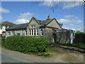
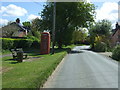
Preston St. Mary
Looks like the Village Hall.
Image: © JThomas
Taken: 25 Apr 2017
0.02 miles
2
Elizabeth II postbox on The Street, Preston St Mary
Postbox No. CO10 1020.
See Image for close up.
Image: © JThomas
Taken: 25 Apr 2017
0.06 miles
3
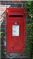
Close up, Elizabeth II postbox on The Street, Preston St Mary
Postbox No. CO10 1020.
See Image for context.
Image: © JThomas
Taken: 25 Apr 2017
0.06 miles
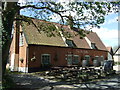
4
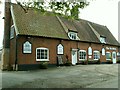
'The Six Bells' inn, Preston St. Mary, Suffolk
Image: © Robert Edwards
Taken: 31 May 2006
0.08 miles
5

Footpath at Preston St Mary
This path leads north-eastwards from the main street of the village, linking with another footpath on the far side of the hedge ahead.
Image: © Bob Jones
Taken: 10 Dec 2009
0.09 miles
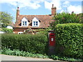
6
The Street, Preston St. Mary
Looking south east.
Image: © JThomas
Taken: 25 Apr 2017
0.10 miles
7

Sign for the Six Bells Inn, Preston St. Mary
Image: © JThomas
Taken: 25 Apr 2017
0.12 miles
9
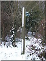
Footpath Sign
Footpath sign near to Preston St.Mary, Suffolk.
Image: © Keith Evans
Taken: 21 Dec 2010
0.20 miles
10
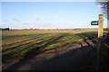
Disappearing footpath
As indicated by the finger post, a public footpath runs across this field, from Church Lane, Preston St Mary. But it has been sowed with winter wheat and all signs of a footpath have been erased.
Image: © Bob Jones
Taken: 10 Dec 2009
0.21 miles