IMAGES TAKEN NEAR TO
Hill Green, Bury Road, SUDBURY, CO10 9LS
Introduction
This page details the photographs taken nearby to Hill Green, Bury Road, CO10 9LS by members of the Geograph project.
The Geograph project started in 2005 with the aim of publishing, organising and preserving representative images for every square kilometre of Great Britain, Ireland and the Isle of Man.

There are currently over 7.5m images from over14,400 individuals and you can help contribute to the project by visiting https://www.geograph.org.uk
Image Map (Loading...)


Getting Data...Please wait
Leaflet Map data © OpenStreetMap
Images are licensed for reuse under creativecommons.org/licenses/by-sa/2.0
Notes
- Clicking on the map will re-center to the selected point.
- The higher the marker number, the further away the image location is from the centre of the postcode.
Image Listing (13 Images Found)
Images are licensed for reuse under creativecommons.org/licenses/by-sa/2.0
Image
Details
Distance
1
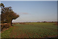
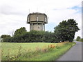
View northward at Likely Hill
Looking north from a minor road towards Knight's Hill, north of Lavenham.
Image: © Bob Jones
Taken: 10 Dec 2009
0.09 miles
2
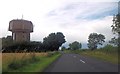
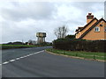
Road approaching the Water Tower on Likely Hill
Image: © Helen Steed
Taken: 29 Jul 2012
0.10 miles
3
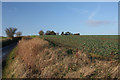
Sunken lane near Lavenham
This little-used lane leads eastwards from the A1141; it passes between high banks on either side. This view westwards takes in the top of the water tower which is situated adjacent to the main road.
Image: © Bob Jones
Taken: 10 Dec 2009
0.11 miles
4
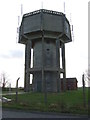
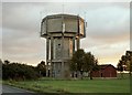
Water Tower
Water tower at Likely Hill near to Lavenham, Suffolk.
Image: © Keith Evans
Taken: 22 Jan 2012
0.11 miles
5

Lavenham: Looking towards the water tower in Bury Road
Image: © Michael Garlick
Taken: 26 Jun 2020
0.12 miles
7
Water Tower
Water tower and road junction near to Lavenham, Suffolk.
Image: © Keith Evans
Taken: 22 Jan 2012
0.12 miles
9
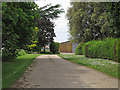
Track to Lavenham Hill Farm
A public footpath runs on this farm track, which adjoins the A1141.
Image: © Roger Jones
Taken: 26 May 2014
0.15 miles
10
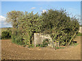
Unique trefoil pillbox Part of the Eastern Command Stop-line
This pillbox is unique to the UK as far as I know. It has a central AA well with the gun post still in place. From this radiates three small (6 x 6 feet) equally spaced (pillbox) areas, each with three loopholes. The central well takes up much of the interior space allowing only narrow passageways between the gun positions. http://www.geograph.org.uk/photo/4196560
It stands in the middle of a field on a promontory overlooking the valley below. The design however does allow for 360 degree visibility and firing.
Image: © Adrian S Pye
Taken: 7 Oct 2014
0.16 miles