IMAGES TAKEN NEAR TO
Meeting Field, SUDBURY, CO10 9JZ
Introduction
This page details the photographs taken nearby to Meeting Field, CO10 9JZ by members of the Geograph project.
The Geograph project started in 2005 with the aim of publishing, organising and preserving representative images for every square kilometre of Great Britain, Ireland and the Isle of Man.

There are currently over 7.5m images from over14,400 individuals and you can help contribute to the project by visiting https://www.geograph.org.uk
Image Map (182 Images)


Leaflet Map data © OpenStreetMap
Images are licensed for reuse under creativecommons.org/licenses/by-sa/2.0
Notes
- Clicking on the map will re-center to the selected point.
- The higher the marker number, the further away the image location is from the centre of the postcode.
Image Listing (182 Images Found)
Images are licensed for reuse under creativecommons.org/licenses/by-sa/2.0
Image
Details
Distance
2
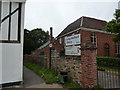
The end of St. Catherine's Road as it meets the B1064
Image: © Robert Edwards
Taken: 10 Sep 2008
0.07 miles
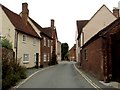
3
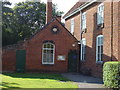
St Catherine's Cottage, Liston Lane, Long Melford
Originally a school.
Image: © Robin Webster
Taken: 21 Aug 2022
0.07 miles
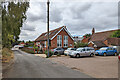
4
Library, Long Melford
And a playgroup, and a footpath sign, on the route of St.Edmund Way.
Image: © Peter Barr
Taken: 14 Sep 2010
0.08 miles

7
Houses on St Catherine's Road, Long Melford
Image: © JThomas
Taken: 20 May 2017
0.09 miles
8
![Long Melford buildings [21]](https://s1.geograph.org.uk/geophotos/06/74/35/6743517_2eda654b_120x120.jpg)
Long Melford buildings [21]
Part of the United Reformed Church in Hall Street Image serves as Long Melford Library. The chapel is listed, grade II, with details at: https://historicengland.org.uk/listing/the-list/list-entry/1284366
Long Melford is a large village in Suffolk near the border with Essex, some 3 miles north of Sudbury. The village gained its name because it stretches for two and three quarter miles essentially along a single road. There is evidence of occupation from every period from the Mesolithic. The village contains two stately homes, Kentwell Hall and Melford Hall, is home to one of the largest and richest "wool churches" in East Anglia with fine flushwork, and a superb almshouse founded in 1573.
Image: © Michael Dibb
Taken: 13 Sep 2020
0.09 miles
9
![Long Melford houses [127]](https://s1.geograph.org.uk/geophotos/06/74/65/6746513_39f02669_120x120.jpg)
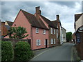
Long Melford houses [127]
Somerset Cottage in Little St Mary's is part of the same building as St Mary's Hall Image, a 16th or 17th century timber framed and stuccoed house refronted in the 18th century. The 18th century bay may have been a former shop window. Listed, grade II, with details at: https://historicengland.org.uk/listing/the-list/list-entry/1351832
Long Melford is a large village in Suffolk near the border with Essex, some 3 miles north of Sudbury. The village gained its name because it stretches for two and three quarter miles essentially along a single road. There is evidence of occupation from every period from the Mesolithic. The village contains two stately homes, Kentwell Hall and Melford Hall, is home to one of the largest and richest "wool churches" in East Anglia with fine flushwork, and a superb almshouse founded in 1573.
Image: © Michael Dibb
Taken: 13 Sep 2020
0.10 miles
10
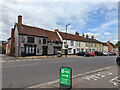
Assorted buildings, Long Melford
On the west side of the main street, all grade II listed.
Image: © Robin Webster
Taken: 21 Aug 2022
0.10 miles