IMAGES TAKEN NEAR TO
Southgate Gardens, SUDBURY, CO10 9HB
Introduction
This page details the photographs taken nearby to Southgate Gardens, CO10 9HB by members of the Geograph project.
The Geograph project started in 2005 with the aim of publishing, organising and preserving representative images for every square kilometre of Great Britain, Ireland and the Isle of Man.

There are currently over 7.5m images from over14,400 individuals and you can help contribute to the project by visiting https://www.geograph.org.uk
Image Map (Loading...)


Getting Data...Please wait
Leaflet Map data © OpenStreetMap
Images are licensed for reuse under creativecommons.org/licenses/by-sa/2.0
Notes
- Clicking on the map will re-center to the selected point.
- The higher the marker number, the further away the image location is from the centre of the postcode.
Image Listing (54 Images Found)
Images are licensed for reuse under creativecommons.org/licenses/by-sa/2.0
Image
Details
Distance
1
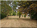
'Green', Southgate Gardens, Long Melford
After a long dry and sometimes hot period.
Image: © Robin Webster
Taken: 21 Aug 2022
0.04 miles
2
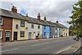
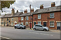
Cottages, Southgate Street, Long Melford
On the B1064, the main road through the small town, although through traffic can use the A134 bypass. Older maps call this long terrace 'Rotten Row', a name possibly quietly forgotten now.
Image: © Robin Webster
Taken: 21 Aug 2022
0.05 miles
3
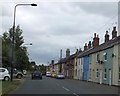
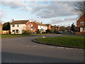
Southgate Street, Long Melford
Long Melford is a long village, running north-south along one main road. These houses are at the southern end of the village; as 19th century terraced housing, they lack garages, so cars are parked on the verge opposite
Image: © David Smith
Taken: 19 Jun 2014
0.05 miles
5
Cottages, Southgate Street, Long Melford
On the B1064, the main road through the small town, although through traffic can use the A134 bypass. Older maps call this long and varied terrace 'Rotten Row'.
Image: © Robin Webster
Taken: 21 Aug 2022
0.06 miles
6
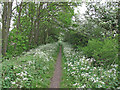
Footpath on the dismantled railway line, Long Melford
This footpath is on the trackbed of the former Long Melford to Bury St. Edmunds branch line which closed in 1965.
Image: © Roger Jones
Taken: 5 May 2014
0.06 miles
7
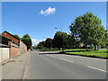
Roman Way, viewed from Little St. Mary's
Image: © Robert Edwards
Taken: 2 Feb 2012
0.06 miles
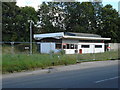
9
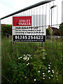
Estate Agents Board
At the former Fuel Filling Station off the B1064 Southgate Street
Image: © Geographer
Taken: 22 May 2014
0.07 miles
10
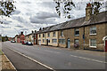
Cottages, Southgate Street, Long Melford
On the B1064, the main road through the small town, although through traffic can use the A134 bypass. Older maps call this long terrace 'Rotten Row'.
Image: © Robin Webster
Taken: 21 Aug 2022
0.07 miles