IMAGES TAKEN NEAR TO
Highbank Drive, SUDBURY, CO10 9FU
Introduction
This page details the photographs taken nearby to Highbank Drive, CO10 9FU by members of the Geograph project.
The Geograph project started in 2005 with the aim of publishing, organising and preserving representative images for every square kilometre of Great Britain, Ireland and the Isle of Man.

There are currently over 7.5m images from over14,400 individuals and you can help contribute to the project by visiting https://www.geograph.org.uk
Image Map (Loading...)


Getting Data...Please wait
Leaflet Map data © OpenStreetMap
Images are licensed for reuse under creativecommons.org/licenses/by-sa/2.0
Notes
- Clicking on the map will re-center to the selected point.
- The higher the marker number, the further away the image location is from the centre of the postcode.
Image Listing (18 Images Found)
Images are licensed for reuse under creativecommons.org/licenses/by-sa/2.0
Image
Details
Distance
1
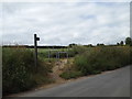
Footpath to Upper Street
Off Upper Street
Image: © Geographer
Taken: 14 Jun 2014
0.11 miles
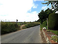
3
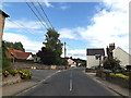
B1066 Lower Street, Stanstead
At the junction with Upper Street
Image: © Geographer
Taken: 14 Jun 2014
0.20 miles
4
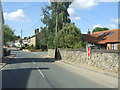
Lower Street, Stanstead
Showing position of Victorian Postbox No. CO10 1030.
See Image] for postbox.
Image: © JThomas
Taken: 2 Sep 2017
0.20 miles
5
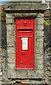
Victorian postbox on Lower Street, Stanstead
Postbox No. CO10 1030.
See Image] for context.
Image: © JThomas
Taken: 2 Sep 2017
0.20 miles
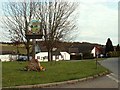
7
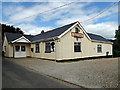
Stanstead Village Community Centre
Off Upper Street at the junction with the B1066 Lower Street
Image: © Geographer
Taken: 14 Jun 2014
0.20 miles
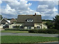
8
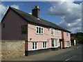
Former public house, Stanstead
On Lower Street (B1066).
Image: © JThomas
Taken: 2 Sep 2017
0.20 miles